Файл:1838NSWMitchell.jpg

Оригинален файл (993 × 719 пиксела, големина на файла: 114 КБ, MIME-тип: image/jpeg)
| Този файл е от Общомедия и може да се използва от други проекти.
Следва информация за файла, достъпна през оригиналната му описателна страница. |
Резюме
| Описание |
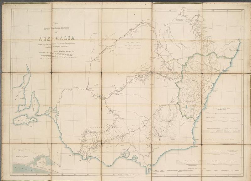
The south eastern portion of Australia showing the routes of the three expeditions and the surveyed territory. Mitchell's map of Victoria and New South Wales showing towns, major rivers and the limits of the Colony at the time. The map shows in red the routes taken by Mitchell's expedition and camps. Major Thomas L. Mitchell's expedition of 1836 was an exploratory one, the aim of which was to develop and expand the Colony of New South Wales and to seek potential grazing and farming land, as well as sites for new settlements. A landmark in Australian history, Mitchell exceeded his orders and discovered and explored a rich pastoral area which he called Australia Felix (Happy Australia) - now central and western Victoria. This map which he compiled is the first properly surveyed map of this part of southeast Australia and it remained in use for many years. |
| Дата | |
| Източник | National Library of Australia |
| Автор | Sir Thomas Mitchell, 1792-1855; NSW Surveyor-General |
| Права (Повторно използване на файла) |
Public Domain - more than 100 years old |
Лицензиране
|
Това произведение е обществено достояние в държавите, в които срокът на авторското право е 70 години или по-малко след смъртта на автора.
| |
| This file has been identified as being free of known restrictions under copyright law, including all related and neighboring rights. | |
История на файла
Избирането на дата/час ще покаже как е изглеждал файлът към онзи момент.
| Дата/Час | Миникартинка | Размер | Потребител | Коментар | |
|---|---|---|---|---|---|
| текуща | 23:03, 8 юли 2006 | | 993 × 719 (114 КБ) | Matilda | {{Information |Description= The south eastern portion of Australia showing the routes of the three expeditions and the surveyed territory. Mitchell's map of Victoria and New South Wales showing towns, major rivers and the limits of the Colony at the time |
Използване на файла
Следната страница използва следния файл:
Глобално използване на файл
Този файл се използва от следните други уикита:
- Употреба в en.wikipedia.org