Файл:Great Basin definition map.gif

Размер на този преглед: 437 × 599 пиксела. Други разделителни способности: 175 × 240 пиксела | 572 × 784 пиксела.
Оригинален файл (572 × 784 пиксела, големина на файла: 50 КБ, MIME-тип: image/gif)
| Този файл е от Общомедия и може да се използва от други проекти.
Следва информация за файла, достъпна през оригиналната му описателна страница. |
Резюме
| Описание |
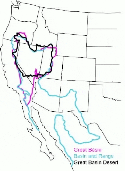
English: The Great Basin can be defined hydrographically (in purple), topographically (in blue), or biologically (in black). |
| Дата | (UTC) |
| Източник |
This file was derived from: GB-Definition-Map.jpg:  |
| Автор |
|
Лицензиране
Original:
| This image or media file contains material based on a work of a National Park Service employee, created as part of that person's official duties. As a work of the U.S. federal government, such work is in the public domain in the United States. See the NPS website and NPS copyright policy for more information. |
Cleanup:
| Този файл е достъпен под лиценза Creative Commons CC0 1.0 Универсален Посвещение на публичните домейни. | |
| The person who associated a work with this deed has dedicated the work to the public domain by waiving all of their rights to the work worldwide under copyright law, including all related and neighboring rights, to the extent allowed by law. You can copy, modify, distribute and perform the work, even for commercial purposes, all without asking permission.
|
Дневник на оригиналното качване
This image is a derivative work of the following images:
- File:GB-Definition-Map.jpg licensed with PD-USGov-NPS
- 2008-01-02T14:23:51Z Psemper 286x392 (17013 Bytes) {{Information |Description= |Source=http://en.wikipedia.org/wiki/Image:GB-Definition-Map.jpg |Date= |Author= |Permission= |other_versions= }}
Uploaded with derivativeFX
История на файла
Избирането на дата/час ще покаже как е изглеждал файлът към онзи момент.
| Дата/Час | Миникартинка | Размер | Потребител | Коментар | |
|---|---|---|---|---|---|
| текуща | 05:38, 23 март 2024 | | 572 × 784 (50 КБ) | Hike395 | optimize gif |
| 03:39, 23 март 2024 |  | 572 × 784 (115 КБ) | Hike395 | == {{int:filedesc}} == {{Information |Description={{en|The {{w|Great Basin}} can be defined hydrographically (in purple), topographically (in blue), or biologically (in black).}} |Source={{Derived from|GB-Definition-Map.jpg|display=50}} |Date=2024-03-23 03:38 (UTC) |Author=* File:GB-Definition-Map.jpg: U.S. National Park Service * cleanup: [[User:{{subst:REVISIONUSER}}|{{subst:REVISIONUSER}}]] |Permission= |other_versions= }} == {{int:license-header}} == Origi... |
Използване на файла
Следната страница използва следния файл:
Глобално използване на файл
Този файл се използва от следните други уикита:
- Употреба в ar.wikipedia.org
- Употреба в arz.wikipedia.org
- Употреба в ast.wikipedia.org
- Употреба в az.wikipedia.org
- Употреба в ca.wikipedia.org
- Употреба в de.wikipedia.org
- Употреба в en.wikipedia.org
- Употреба в es.wikipedia.org
- Употреба в eu.wikipedia.org
- Употреба в gd.wikipedia.org
- Употреба в he.wikipedia.org
- Употреба в hu.wikipedia.org
- Употреба в hy.wikipedia.org
- Употреба в ja.wikipedia.org
- Употреба в ka.wikipedia.org
- Употреба в nl.wikipedia.org
- Употреба в pt.wikipedia.org
- Употреба в ro.wikipedia.org
- Употреба в ru.wikipedia.org
- Употреба в simple.wikipedia.org
- Употреба в sv.wikipedia.org
- Употреба в tr.wikipedia.org
- Употреба в uk.wikipedia.org
- Употреба в vi.wikipedia.org
- Употреба в war.wikipedia.org
- Употреба в www.wikidata.org