Файл:LuxembourgPartitionsMap bg.jpg
Не е налична версия с по-висока разделителна способност.
LuxembourgPartitionsMap_bg.jpg (432 × 558 пиксела, големина на файла: 46 КБ, MIME-тип: image/jpeg)
| Този файл е от Общомедия и може да се използва от други проекти.
Следва информация за файла, достъпна през оригиналната му описателна страница. |

|
Това изображение (или всички изображения в тази страница/категория) би трябвало да бъдат пресъздадени с използване на векторна графика във формат SVG. Това има няколко предимства; вижте Commons:Media for cleanup за повече информация. Ако разполагате с това избражение в SVG формат, моля качете го. След това заместете този шаблон с {{Vector version available|име на новия файл.svg}}.
|


| Описание |
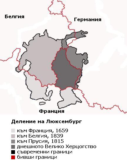
Български: Карта, показваща делението на Люксембург през вековете, с надписи на български.
English: Map showing the partition of Luxembourg through the centuries with Bulgarian explanations.
Français : Carte montrant la partition du Luxembourg à travers les siècles, avec explications en bulgare. |
| Дата | |
| Източник | |
| Автор |
|
| други версии |
|


| This is a retouched picture, which means that it has been digitally altered from its original version. Modifications: translated to Bulgarian. The original can be viewed here: LuxembourgPartitionsMap english.jpg:
|
Аз, носителят на авторските права над тази творба, я публикувам тук под следния лиценз:
| Аз, носителят на авторските права над тази творба, я публикувам като обществено достояние. Това разрешение е в сила за целия свят. В някои държави това може да не е възможно от законодателна гледна точка; затова: Давам на всекиго правото да използва тази творба за всякакви цели, без никакви условия, освен ако такива условия съществуват по закон. |
Дневник на оригиналното качване
This image is a derivative work of the following images:
- File:LuxembourgPartitionsMap_english.jpg licensed with PD-self
- 2008-07-21T18:11:56Z Pretty Green 433x569 (47160 Bytes) {{Information |Description= As previous, with rivers removed from map for clarity |Source= previous version |Date= 21 July 2008 |Author= Spanish Inquisition, modified by Pretty Green |Permission= |other_versions= }}
- 2006-09-03T14:58:29Z Spanish Inquisition 433x569 (83793 Bytes) Map showing the partition of Luxembourg thorugh the centuries with english expanantions. Modification of the image LuxembourgPartitionsMap.png by user:QuartierLatin1968 14:10, 22 Apr 2005 (UTC). Author: user:Spanish_Inquisit
Uploaded with derivativeFX
История на файла
Избирането на дата/час ще покаже как е изглеждал файлът към онзи момент.
| Дата/Час | Миникартинка | Размер | Потребител | Коментар | |
|---|---|---|---|---|---|
| текуща | 14:20, 8 септември 2009 | | 432 × 558 (46 КБ) | Spiritia | {{Information |Description= {{bg|Карта, показваща делението на Люксевбург през вековете, с надписи на български. }} {{en|Map showing the partition of Luxembourg through the centuries with B |
Използване на файла
Следната страница използва следния файл: