Файл:Montenegro Map.png

Оригинален файл (2427 × 1807 пиксела, големина на файла: 1,03 МБ, MIME-тип: image/png)
| Този файл е от Общомедия и може да се използва от други проекти.
Следва информация за файла, достъпна през оригиналната му описателна страница. |
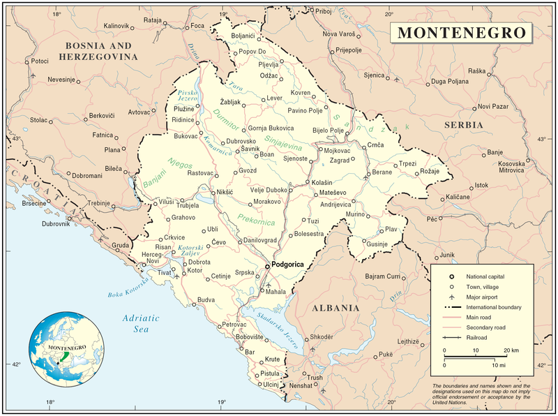
Map of Montenegro
| Описание | Map of Montenegro | |||
| Дата | ||||
| Източник | The Cartographic Section of the United Nations (CSUN) | |||
| Автор | Cartographer of the United Nations | |||
| Права (Повторно използване на файла) |
|

История на файла
Избирането на дата/час ще покаже как е изглеждал файлът към онзи момент.
| Дата/Час | Миникартинка | Размер | Потребител | Коментар | |
|---|---|---|---|---|---|
| текуща | 17:03, 10 март 2007 | | 2427 × 1807 (1,03 МБ) | Minestrone | Map of Montenegro {{Information |Description=Map of Montenegro |Source=The Cartographic Section of the United Nations (CSUN) |Date=2007-03-10 |Author=Cartographer of the United Nations |Permission={{Template:UN map}} and the cartographer of the UN [ |
Използване на файла
Следната страница използва следния файл:
Глобално използване на файл
Този файл се използва от следните други уикита:
- Употреба в als.wikipedia.org
- Употреба в ar.wikipedia.org
- Употреба в avk.wikipedia.org
- Употреба в be-tarask.wikipedia.org
- Употреба в cs.wikipedia.org
- Употреба в cy.wikipedia.org
- Употреба в de.wikipedia.org
- Употреба в el.wikipedia.org
- Употреба в en.wikipedia.org
- Употреба в fa.wikipedia.org
- Употреба в fr.wikipedia.org
- Употреба в gag.wikipedia.org
- Употреба в gd.wikipedia.org
- Употреба в hr.wiktionary.org
- Употреба в ia.wikipedia.org
- Употреба в incubator.wikimedia.org
- Употреба в io.wikipedia.org
- Употреба в ka.wikipedia.org
- Употреба в la.wikipedia.org
- Употреба в ms.wikipedia.org
- Употреба в nl.wikipedia.org
- Употреба в pl.wikipedia.org
- Употреба в pl.wiktionary.org
- Употреба в pnb.wikipedia.org
- Употреба в ps.wikipedia.org
- Употреба в rm.wikipedia.org
- Употреба в roa-tara.wikipedia.org
- Употреба в ro.wikipedia.org
- Употреба в ro.wikivoyage.org
- Употреба в ru.wikipedia.org
Преглед на глобалната употреба на файла.