Оригинален файл(1256 × 656 пиксела, големина на файла: 75 КБ, MIME-тип: image/png)

Емблемата на Общомедия Този файл е от Общомедия и може да се използва от други проекти.

Следва информация за файла, достъпна през оригиналната му описателна страница.

Резюме

Това изображение (или всички изображения в тази страница/категория) би трябвало да бъдат пресъздадени с използване на векторна графика във формат SVG. Това има няколко предимства; вижте Commons:Media for cleanup за повече информация. Ако разполагате с това избражение в SVG формат, моля качете го. След това заместете този шаблон с {{Vector version available|име на новия файл.svg}}.
Описание
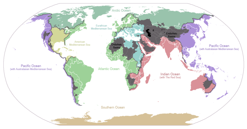
English: I made this map and hereby release it into the public domain. It shows the drainage basins for the major oceans and seas; grey areas are endorheic basins that do not drain to the ocean. Data is from the USGS Hydro1k project; information for Saskatchewan corrected by information from the Commission for Environmental Cooperation -- Citynoise
Description in large font size is used for oceans, in smaller font size is used for mediterranean seas. Only these mediterranean seas are listed which correspond to the definition of german Geographer Ernst Neef: A mediterranean sea is a sea between two Continents. Also found here: de:Mittelmeer --W like wiki (talk) 00:55, 12 March 2011 (UTC)
Français : Carte du monde des bassins versants. Les zones de couleur anthracite représentent les bassins endoréiques, qui ne sont reliés à aucun océan.
Čeština: Úmoří světových oceánů, popř. významných moří či zálivů. Legenda úmoří: fialová - Tichý oceán, růžová - Indický oceán, zelená - Atlantický oceán, azurová - Severní ledový oceán, béžová - Jižní oceán, modrá - Mexický záliv, světle modrá - Středozemní moře, šedá - oblast neústící ve světovém oceánu
Дата 24 януари 2007 (original upload date)
Източник Прехвърлен от en.wikipedia към Общомедия.
Автор Citynoise at английски Уикипедия
други версии File:Major endorheic basins.png

Лицензиране

Public domain Тази творба е публикувана от своя автор, Citynoise at английски Уикипедия, като обществено достояние. Това разрешение е в сила за целия свят.
В някои държави това може да не е възможно от законодателна гледна точка; затова:
Citynoise дава на всекиго правото да използва тази творба за всякакви цели, без никакви условия, освен ако такива условия съществуват по закон.

Дневник на оригиналното качване

The original description page was here. All following user names refer to en.wikipedia.
  • 2007-05-20 17:59 Bolonium 1256×656×8 (50194 bytes) I made this map and hereby release it into the public domain. It shows the drainage basins for the major oceans and seas; grey areas are endorheic basins that do not drain to the ocean. -- [[User:Citynoise|Citynoise]] == Licensing == {{self
  • 2007-01-24 07:21 Citynoise 1256×656×8 (63359 bytes) I made this map and hereby release it into the public domain. It shows the drainage basins for the major oceans and seas; grey areas are endorheic basins that do not drain to the ocean.
  • 2007-01-24 06:09 Citynoise 1256×656×8 (57358 bytes) I made this map and hereby release it into the public domain. It shows the drainage basins for the major oceans and seas; grey areas are endorheic basins that do not drain to the ocean.
  • 2007-01-24 05:10 Citynoise 1256×656×8 (56360 bytes) I made this map and hereby release it into the public domain. It shows the drainage basins for the major oceans and seas; grey areas are endorheic basins that do not drain to the ocean.
  • 2007-01-24 04:55 Citynoise 1256×656×8 (56373 bytes) I made this map and hereby release it into the public domain. It shows the drainage basins for the major oceans and seas; grey areas are endorheic basins that do not drain to the ocean.

Описания

Add a one-line explanation of what this file represents
Drainage basins of the world, colored by ocean outlet. Endorheic basins not draining to an ocean are colored dark gray. Continental divides are indicated by dark lines.

Items portrayed in this file

изобразен обект

История на файла

Избирането на дата/час ще покаже как е изглеждал файлът към онзи момент.

Дата/ЧасМиникартинкаРазмерПотребителКоментар
текуща23:25, 6 октомври 2015Миникартинка на версията към 23:25, 6 октомври 20151256 × 656 (75 КБ)AcidSnowFixed Somalia.
00:39, 12 март 2011Миникартинка на версията към 00:39, 12 март 20111256 × 656 (76 КБ)W like wikiInsert Description. Big font size is used for oceans, smaller font size is used for mediterranean seas.
11:13, 30 юни 2009Миникартинка на версията към 11:13, 30 юни 20091256 × 656 (40 КБ)U7vGuntransparentize background,improve some details.
20:45, 26 юли 2008Миникартинка на версията към 20:45, 26 юли 20081256 × 656 (62 КБ)Citynoise{{Information |Description=added endorheic basins in Saskatchewan. |Source=my own work |Date=July 2008 |Author=Citynoise |Permission=all rights released |other_versions= }}
19:46, 27 ноември 2007Миникартинка на версията към 19:46, 27 ноември 20071256 × 656 (49 КБ)File Upload Bot (Magnus Manske) {{BotMoveToCommons|en.wikipedia}} {{Information |Description={{en|I made this map and hereby release it into the public domain. It shows the drainage basins for the major oceans and seas; grey areas are en:endorheic basins that do not drain to the

Следната страница използва следния файл:

Глобално използване на файл

Този файл се използва от следните други уикита:

Преглед на глобалната употреба на файла.

Метаданни