Файл:Austrian Netherlands 1789.svg

Размер на този PNG предварителен преглед на изходния SVG файл: 450 × 456 пиксела. Други разделителни способности: 237 × 240 пиксела | 474 × 480 пиксела | 758 × 768 пиксела | 1011 × 1024 пиксела | 2021 × 2048 пиксела.
Оригинален файл (Файл във формат SVG, основен размер: 450 × 456 пиксела, големина на файла: 858 КБ)
| Този файл е от Общомедия и може да се използва от други проекти.
Следва информация за файла, достъпна през оригиналната му описателна страница. |
Резюме


.svg)
.svg)
.svg)
.svg)
.svg)


.svg)
.svg)
.svg)


.png)
.png)


.svg)


.svg)

.svg)


.svg)
.svg)
.svg)
.svg)


.svg)
.png)


.svg)


.svg)
.svg)


.svg)


.svg)


.svg)
.svg)
.svg)
.svg)
.svg)
.svg)
.svg)
_cropped.svg)
.svg)
.svg)
.svg)
.svg)
.svg)
.svg)
.svg)
.svg)
.svg)
.svg)
.svg)
.svg)
.svg)
.svg)
.svg)
.svg)
.svg)
.svg)
.svg)
.svg)
.svg)
.svg)
.svg)
.svg)
.svg)
.svg)
.svg)
.svg)
.svg)
.svg)
.svg)
.svg)
.svg)
.svg)
.svg)
.svg)
.svg)
.svg)
.svg)
.svg)
.svg)
.svg)
.svg)
.svg)
.svg)
Лицензиране
Аз, носителят на авторските права над тази творба, я публикувам тук под следния лиценз:
Този файл се разпространява под лиценз Криейтив Комънс Признание — Споделяне на споделеното 3.0.
- Можете свободно:
- да споделяте – да копирате, разпространявате и излъчвате произведението
- да ремиксирате – да адаптирате произведението
- Съгласно следните условия:
- признание на авторството – Трябва да посочите авторството, да добавите връзка към лиценза и да посочите дали са правени промени. Можете да направите това по всякакъв разумен начин, но не и по начин, оставящ впечатлението, че същият/същите подкрепят вас или използването по някакъв начин на творбата от вас.
- споделяне на споделеното – В случай, че промените, видоизмените или използвайки като основа произведението, го надградите, то полученото производно произведение може да се разпространява само съгласно условията на същия или съвместим лиценз с оригиналния такъв.
Дневник на оригиналното качване
This image is a derivative work of the following images:
- File:Europe_1789.svg licensed with Cc-by-sa-3.0
- 2013-04-14T03:44:26Z Alphathon 450x456 (858577 Bytes) Corrected some errors in northern Italy
- 2013-04-14T01:38:01Z Alphathon 450x456 (853881 Bytes) tweaked again
- 2013-04-14T01:36:10Z Alphathon 450x456 (853881 Bytes) Tweaked Holy Roman Empire border style
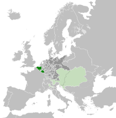
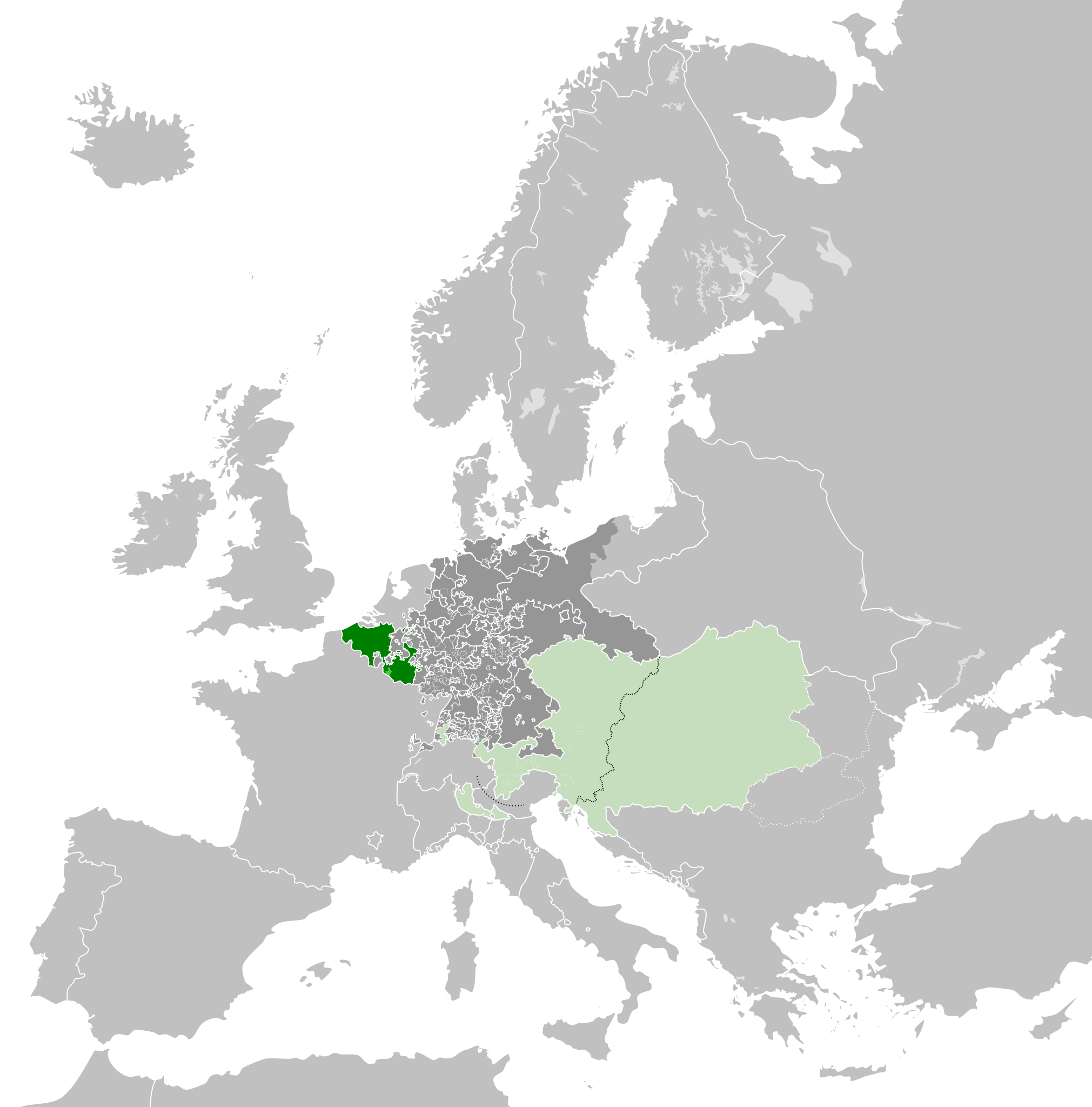
- 2013-04-14T01:33:26Z Alphathon 450x456 (853857 Bytes) == {{int:filedesc}} == {{Information |Description={{en|A blank Map of Europe circa 1789. This map also includes a border for the [[:en:Holy Roman Empire|Holy Roman Empire]]. Since there are so many small German states, they h
Uploaded with derivativeFX
История на файла
Избирането на дата/час ще покаже как е изглеждал файлът към онзи момент.
| Дата/Час | Миникартинка | Размер | Потребител | Коментар | |
|---|---|---|---|---|---|
| текуща | 07:38, 17 октомври 2021 | | 450 × 456 (858 КБ) | Fenn-O-maniC | Wrong file |
| 07:38, 17 октомври 2021 |  | 450 × 456 (800 КБ) | Fenn-O-maniC | Fixed the Russo-Swedish border to match the Treaty of Åbo of 1743 | |
| 07:36, 17 октомври 2021 |  | 450 × 456 (858 КБ) | Fenn-O-maniC | Fixed the Russo-Swedish border to match the Treaty of Åbo of 1743 | |
| 20:34, 18 април 2013 |  | 450 × 456 (878 КБ) | Alphathon | Style change | |
| 18:34, 18 април 2013 |  | 450 × 456 (857 КБ) | Alphathon | Various fixes | |
| 20:31, 15 април 2013 |  | 450 × 456 (854 КБ) | Alphathon | Corrected Scandinavian borders | |
| 23:18, 14 април 2013 |  | 450 × 456 (839 КБ) | Alphathon | Changed colour of the remainder of the Habsburg Monarchy | |
| 13:29, 14 април 2013 |  | 450 × 456 (839 КБ) | Alphathon | == {{int:filedesc}} == {{Information |Description={{en|A map of the Austrian Netherlands within the Habsburg Monarchy, the Holy Roman Empire and Europe circa 1789.}}{{de|Eine Landkarte die [[:de:Öste... |
Използване на файла
Следната страница използва следния файл:
Глобално използване на файл
Този файл се използва от следните други уикита:
- Употреба в ar.wikipedia.org
- Употреба в ast.wikipedia.org
- Употреба в cs.wikipedia.org
- Употреба в en.wikipedia.org
- Употреба в eo.wikipedia.org
- Употреба в et.wikipedia.org
- Употреба в eu.wikipedia.org
- Употреба в fa.wikipedia.org
- Употреба в fi.wikipedia.org
- Употреба в fr.wikipedia.org
- Употреба в gl.wikipedia.org
- Употреба в he.wikipedia.org
- Употреба в id.wikipedia.org
- Употреба в is.wikipedia.org
- Употреба в it.wikipedia.org
- Употреба в ja.wikipedia.org
- Употреба в ko.wikipedia.org
- Употреба в lv.wikipedia.org
- Употреба в mk.wikipedia.org
- Употреба в pt.wikipedia.org
- Употреба в th.wikipedia.org
- Употреба в tr.wikipedia.org
- Употреба в uk.wikipedia.org
- Употреба в vi.wikipedia.org
- Употреба в www.wikidata.org
- Употреба в zh.wikipedia.org