Файл:BNR (Ruthienie Blanche) Map 1918.jpg

Оригинален файл (4400 × 3015 пиксела, големина на файла: 10,27 МБ, MIME-тип: image/jpeg)
| Този файл е от Общомедия и може да се използва от други проекти.
Следва информация за файла, достъпна през оригиналната му описателна страница. |
_Map_1918.jpg)
Резюме
| Заглавие |
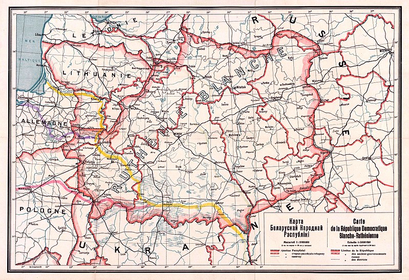
Беларуская: Карта Беларускай Народнай Рэспублікі, 1918 Беларуская (тарашкевіца): Мапа Беларускай Народнай Рэспублікі, 1918
English: Map of the territory claimed by the Belarusian People's Republic (published in 1918).
Русский: Карта Белорусской Народной Республики, 1918
Українська: Карта Білоруської Народної Республіки, 1918 |
| Дата | |
| Източник |
1. Карта БНР 1918 год, IMAGO.BY 2. Originally uploaded to English Wikipedia by Rydel (21:53, 2 January 2005) as en:Image:BNR ruthienie blanche.jpg. |
| Създател |
Неизвестен |
| Georeferencing | If inappropriate please set warp_status = skip to hide. |
Лицензиране
|
Това произведение е обществено достояние в държавите, в които срокът на авторското право е 70 години или по-малко след смъртта на автора.
| |
| This file has been identified as being free of known restrictions under copyright law, including all related and neighboring rights. | |
История на файла
Избирането на дата/час ще покаже как е изглеждал файлът към онзи момент.
| Дата/Час | Миникартинка | Размер | Потребител | Коментар | |
|---|---|---|---|---|---|
| текуща | 13:56, 26 октомври 2017 | | 4400 × 3015 (10,27 МБ) | Kazimier Lachnovič | better quality |
| 14:18, 3 септември 2005 |  | 1000 × 700 (195 КБ) | EugeneZelenko | Map of Belarusian National Republic (published in 1918). Originally uploaded to English Wikipedia by Rydel (21:53, 2 January 2005) as en:Image:BNR ruthienie blanche.jpg. Category:Historical maps of Belarus |
Използване на файла
Следната страница използва следния файл:
Глобално използване на файл
Този файл се използва от следните други уикита:
- Употреба в ar.wikipedia.org
- Употреба в ast.wikipedia.org
- Употреба в be-tarask.wikipedia.org
- Употреба в be.wikipedia.org
- Употреба в ca.wikipedia.org
- Употреба в cs.wikipedia.org
- Употреба в cy.wikipedia.org
- Употреба в da.wikipedia.org
- Употреба в de.wikipedia.org
- Употреба в en.wikipedia.org
- Употреба в eo.wikipedia.org
- Употреба в es.wikipedia.org
- Употреба в et.wikipedia.org
- Употреба в eu.wikipedia.org
- Употреба в fr.wikipedia.org
- Употреба в hu.wikipedia.org
Преглед на глобалната употреба на файла.
_Map_1918.jpg)
_Map_1918.jpg)