Файл:CraterHighlands Tanzania NASA.jpg
Размер на този преглед: 484 × 600 пиксела. Други разделителни способности: 194 × 240 пиксела | 540 × 669 пиксела.
Оригинален файл (540 × 669 пиксела, големина на файла: 118 КБ, MIME-тип: image/jpeg)
| Този файл е от Общомедия и може да се използва от други проекти.
Следва информация за файла, достъпна през оригиналната му описателна страница. |
Резюме
| Описание |
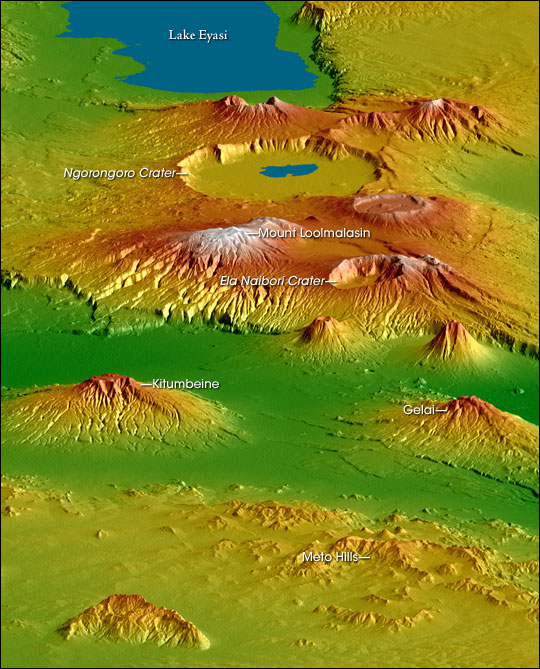
English: Topographical map of the w:Crater Highlands in Tanzania. Color indicates height, with lowest elevations in green and highest elevations in white. Shading shows the slope. The vertical relief has been exaggerated by a factor of 2 to reveal greater detail about the landscape. The image is oriented as though you were looking from the north toward the southwest.
Afrikaans: Topografiese kaart van Tanzanië se kraterhooglande. Kleur dui hoogte aan, met laagste gebiede in groen en hoogste hoogtes in wit. Skadu dui hellings aan, en die vertikale reliëf is verdubbel om meer landskapdetail weer te gee. Die uitsig is georiënteer van die noordooste na suidweste. Natronmeer is net buite sig aan regterhand. |
| Дата | |
| Източник | https://earthobservatory.nasa.gov/IOTD/view.php?id=6316 |
| Автор | Robert E. Crippen, NASA/JPL Shuttle Radar Topography Mission team. Labels by NASA Earth Observatory newsroom. |
| Права (Повторно използване на файла) |
US government, public domain. |
| други версии |
Derivative works of this file: CraterHighlands Tanzania NASA unannotated.jpg Larger, unannotated version available at source URL. |
Лицензиране
| This file is in the public domain in the United States because it was solely created by NASA. NASA copyright policy states that "NASA material is not protected by copyright unless noted". (See Template:PD-USGov, NASA copyright policy page or JPL Image Use Policy.) | ||
 |
Warnings:
|
История на файла
Избирането на дата/час ще покаже как е изглеждал файлът към онзи момент.
| Дата/Час | Миникартинка | Размер | Потребител | Коментар | |
|---|---|---|---|---|---|
| текуща | 17:53, 28 април 2006 | | 540 × 669 (118 КБ) | Holly Cheng | {{Information | Description=Topographical map of the w:Crater Highlands in Tanzania. Color indicates height, with lowest elevations in green and highest elevations in white. Shading shows the slope. The vertical relief has been exaggerated by a factor |
Използване на файла
Няма страници, използващи файла.
Глобално използване на файл
Този файл се използва от следните други уикита:
- Употреба в arz.wikipedia.org
- Употреба в avk.wikipedia.org
- Употреба в ceb.wikipedia.org
- Употреба в de.wikipedia.org
- Употреба в el.wikipedia.org
- Употреба в en.wikipedia.org
- Употреба в es.wikipedia.org
- Употреба в fr.wikipedia.org
- Употреба в he.wikipedia.org
- Употреба в hr.wikipedia.org
- Употреба в ru.wikipedia.org
- Употреба в sh.wikipedia.org
- Употреба в sl.wikipedia.org
- Употреба в sr.wikipedia.org
- Употреба в sw.wikipedia.org
- Употреба в uk.wikipedia.org
- Употреба в www.wikidata.org
- Употреба в zh.wikipedia.org