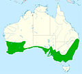
Файл:Distribution red wattlebird.jpg

Размер на този преглед: 667 × 599 пиксела. Други разделителни способности: 267 × 240 пиксела | 534 × 480 пиксела | 855 × 768 пиксела | 1140 × 1024 пиксела | 2056 × 1847 пиксела.
Оригинален файл (2056 × 1847 пиксела, големина на файла: 325 КБ, MIME-тип: image/jpeg)
История на файла
Избирането на дата/час ще покаже как е изглеждал файлът към онзи момент.
| Дата/Час | Миникартинка | Размер | Потребител | Коментар | |
|---|---|---|---|---|---|
| текуща | 10:48, 7 февруари 2016 |  | 2056 × 1847 (325 КБ) | Aa77zz | Expand range in arid area of southern WA south of Laverton based on Birddata. The low density of reported sightings makes it difficult to know where to draw the line. Also move boundary north of Murray River, the Victoria NSW boundary. Note that there... |
| 21:47, 6 февруари 2016 |  | 2056 × 1847 (326 КБ) | Aa77zz | Improved colouring | |
| 18:09, 6 февруари 2016 |  | 2056 × 1847 (334 КБ) | Aa77zz | User created page with UploadWizard |
Използване на файла
Следната страница използва следния файл:
Глобално използване на файл
Този файл се използва от следните други уикита:
- Употреба в ar.wikipedia.org
- Употреба в arz.wikipedia.org
- Употреба в ast.wikipedia.org
- Употреба в br.wikipedia.org
- Употреба в ca.wikipedia.org
- Употреба в ceb.wikipedia.org
- Употреба в cy.wikipedia.org
- Употреба в en.wikipedia.org
- Употреба в eu.wikipedia.org
- Употреба в hu.wikipedia.org
- Употреба в nv.wikipedia.org
- Употреба в pl.wikipedia.org
- Употреба в sv.wikipedia.org
- Употреба в tr.wikipedia.org
- Употреба в uk.wikipedia.org
- Употреба в www.wikidata.org
- Употреба в zh.wikipedia.org
