Файл:First French Empire 1812.svg

Размер на този PNG предварителен преглед на изходния SVG файл: 450 × 456 пиксела. Други разделителни способности: 237 × 240 пиксела | 474 × 480 пиксела | 758 × 768 пиксела | 1011 × 1024 пиксела | 2021 × 2048 пиксела.
Оригинален файл (Файл във формат SVG, основен размер: 450 × 456 пиксела, големина на файла: 464 КБ)
| Този файл е от Общомедия и може да се използва от други проекти.
Следва информация за файла, достъпна през оригиналната му описателна страница. |
Резюме


.svg)
.svg)
.svg)
.svg)
.svg)


.svg)
.svg)
.svg)


.png)
.png)


.svg)


.svg)

.svg)


.svg)
.svg)
.svg)
.svg)


.svg)
.png)


.svg)


.svg)
.svg)


.svg)


.svg)


.svg)
.svg)
.svg)
.svg)
.svg)
.svg)
.svg)
.svg)
_cropped.svg)
.svg)
.svg)
.svg)
.svg)
.svg)
.svg)
.svg)
.svg)
.svg)
.svg)
.svg)
.svg)
.svg)
.svg)
.svg)
.svg)
.svg)
.svg)
.svg)
.svg)
.svg)
.svg)
.svg)
.svg)
.svg)
.svg)
.svg)
.svg)
.svg)
.svg)
.svg)
.svg)
.svg)
.svg)
.svg)
.svg)
.svg)
.svg)
.svg)
.svg)
.svg)
.svg)
.svg)
.svg)
.svg)
Лицензиране
Този файл се разпространява под лиценз Криейтив Комънс Признание — Споделяне на споделеното 3.0.
- Можете свободно:
- да споделяте – да копирате, разпространявате и излъчвате произведението
- да ремиксирате – да адаптирате произведението
- Съгласно следните условия:
- признание на авторството – Трябва да посочите авторството, да добавите връзка към лиценза и да посочите дали са правени промени. Можете да направите това по всякакъв разумен начин, но не и по начин, оставящ впечатлението, че същият/същите подкрепят вас или използването по някакъв начин на творбата от вас.
- споделяне на споделеното – В случай, че промените, видоизмените или използвайки като основа произведението, го надградите, то полученото производно произведение може да се разпространява само съгласно условията на същия или съвместим лиценз с оригиналния такъв.
Дневник на оригиналното качване
This image is a derivative work of the following images:
- File:Blank_map_of_Europe.svg licensed with Cc-by-sa-2.5
- 2011-09-19T22:57:58Z Alphathon 680x520 (603759 Bytes) Added North/Northern Cyprus
- 2011-08-23T10:26:48Z Heb 680x520 (604212 Bytes) Added [[:en:Bornholm]] (taken from [[:File:Denmark blank map.svg]])
- 2011-04-12T00:40:40Z Alphathon 680x520 (602549 Bytes) Upgraded Sicily based on "File:Freeworldmaps-sicily.jpg". Upgraded Malta based on "File:Map of Malta 2.png". Simplified Croatian borders.
- 2011-04-10T21:43:04Z Alphathon 680x520 (607359 Bytes) Upgraded Croatia, Bosnia & Herzegovina, Slovenia and surrounding countries based on data from "File:Kroatien - Politische Gliederung (Karte).png"
- 2011-04-10T20:05:09Z Alphathon 680x520 (568373 Bytes) Improved Serbia, Montenegro and surrounding countries using data from "File:Serbia Map.png". Fixed Serbia-Montenegro border. Added Kosovo (using dashed border, since it is not a universally recognised nation, and left the lan
- 2011-04-10T15:55:02Z Alphathon 680x520 (524980 Bytes) Tweaked Ukraine and surrounding countries based on data from "File:Up-map.png"
- 2011-04-10T04:02:09Z Alphathon 680x520 (511168 Bytes) Improved Greece, Albania, F.Y.R. Macedonia and Bulgaria based on "File:Greece topo.jpg"
- 2011-04-10T02:48:52Z Alphathon 680x520 (505569 Bytes) Tweaked Germany and surrounding countries based on info from "File:Germany_general_map.png"
- 2011-04-10T01:54:05Z Alphathon 680x520 (493733 Bytes) Converted all lakes back to separate layer. Added Finish lakes and tweaked Finland shape based on "File:Finland 1996 CIA map.jpg". Added Swiss lakes based on "File:Suisse cantons.svg". Tweaked Scotland and added Lochs.
- 2011-04-10T00:07:54Z Alphathon 680x520 (450120 Bytes) Improved England outline and added Isle of Wight based on "File:England Regions - Blank.svg". Improved Denmark based on "File:2 digit postcode danmark.png". Improved Sweden based on "File:Map of Sweden, CIA, 1996.jpg"
- 2011-04-08T15:53:07Z Alphathon 680x520 (438878 Bytes) Upgraded/fixed various parts of the map. Details: *Some minor fixes to Ireland and added some of the larger lakes based on [[:File:Ireland_trad_counties_named.svg]] *Pretty major fixes to Scotland (mainly the west coast and i
- 2008-09-17T09:50:25Z F7 680x520 (531491 Bytes)
- 2008-09-17T09:42:57Z F7 680x520 (2353 Bytes)
- 2008-05-26T19:04:07Z Collard 680x520 (531491 Bytes) uploading on behalf of [[User:Checkit]], direct complaints to him plox: 'Moved countries out of the "outlines" group, removed "outlines" style class, remove separate style information for Russia'
- 2008-04-30T01:38:52Z TimothyBourke 680x520 (531767 Bytes) Changed the country code of Serbia to RS per [http://en.wikipedia.org/wiki/Serbian_country_codes] and the file [http://www.iso.org/iso/iso3166_en_code_lists.txt].
- 2008-02-08T22:44:37Z CarolSpears 680x520 (531767 Bytes) validated
- 2007-07-10T11:47:59Z MrWeeble 680x520 (533112 Bytes) Updated to include British Crown Dependencies as seperate entities and regroup them as "British Islands", with some simplifications to the XML and CSS
- 2007-05-14T17:17:34Z Zirland 680x520 (540659 Bytes) serbia and montenegro
- 2007-03-30T20:40:49Z W!B: 680x520 (538830 Bytes) minor corr: update nl:Ijsselmeer, del fi:lakes (all small), add ru:lake Oneka (all ref maps.google), glued northern irland back to ie ;)
- 2007-02-05T18:44:32Z Maix 680x520 (538295 Bytes) cropped
- 2007-02-04T15:07:29Z Maix 680x520 (538310 Bytes) {{Information |Description=A blank Map of Europe in SVG format. Every country has an id which is its ISO-3116-1-ALPHA2 code in lower case for easy coloring. |Source=Image based on [[Image:Europe_countries.svg|]] by [[User:Ti
Uploaded with derivativeFX
История на файла
Избирането на дата/час ще покаже как е изглеждал файлът към онзи момент.
| Дата/Час | Миникартинка | Размер | Потребител | Коментар | |
|---|---|---|---|---|---|
| текуща | 18:29, 30 юли 2012 | | 450 × 456 (464 КБ) | Alphathon | Prinicpalities |
| 00:14, 25 април 2012 |  | 450 × 456 (462 КБ) | Alphathon | Naming of objects | |
| 23:50, 24 април 2012 |  | 450 × 456 (462 КБ) | Alphathon | Added the Septinsular Republic. | |
| 01:53, 21 февруари 2012 |  | 450 × 456 (459 КБ) | Alphathon | +Semi-autonomous Ottoman states | |
| 21:10, 19 февруари 2012 |  | 450 × 456 (437 КБ) | Alphathon | Fixed Portugal | |
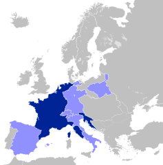
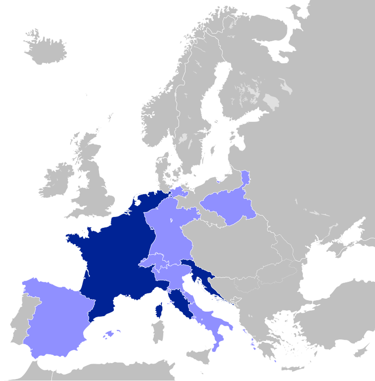
| 21:06, 19 февруари 2012 |  | 450 × 456 (437 КБ) | Alphathon | == {{int:filedesc}} == {{Information |Description=A map of the First French Empire in 1812. |Source={{Derived from|Blank_map_of_Europe.svg|display=50}} |Date=2012-02-19 21:04 (UTC) |Author=*File:Blank_map_of_Europe.svg: maix<sup>[[User |
Използване на файла
Следните 3 страници използват следния файл:
Глобално използване на файл
Този файл се използва от следните други уикита:
- Употреба в ar.wikipedia.org
- الحروب النابليونية
- جمهورية لكة
- مملكة نابولي
- مملكة بافاريا
- مملكة ساكسونيا
- مملكة فورتمبيرغ
- دوقية تسكانة الكبرى
- الجمهورية الألبية
- فتسلار
- دوقية بينيفينتو
- دوقية ماسا وكرارا
- اتحاد الراين
- مملكة إيطاليا النابوليونية
- جمهورية إيطاليا النابوليونية
- جمهورية شقيقة
- الجمهورية الرومانية (القرن 18)
- الجمهورية الليغورية
- دوقية بيرغ الكبرى
- مملكة فستفالن
- دوقية بادن الكبرى
- الجمهورية البارثينوبية
- دوقية هسن الكبرى
- إمارة ريغنسبورغ
- دوقية فورتسبورغ الكبرى
- دوقية فرانكفورت الكبرى
- إمارة زالم
- إمارة لاين
- الجمهورية الباتافية
- المملكة الهولندية
- جمهورية ألبا
- جمهورية لياج
- قالب:دول عميلة في الثورة الفرنسية وحروب نابليون
- مملكة إسبانيا النابليونية
- دوقية وارسو
- مدينة دانزيغ الحرة النابليونية
- سويسرا في العهد النابليوني
- الثورة الأيرلندية 1798
- مملكة إتروريا
- أقاليم إيليرية
- الجمهورية الهيلفيتية
- Употреба в ast.wikipedia.org
- Употреба в ca.wikipedia.org
- Употреба в ckb.wikipedia.org
- Употреба в el.wikipedia.org
Преглед на глобалната употреба на файла.