Файл:Hudson bay explorer.png
Hudson_bay_explorer.png (550 × 442 пиксела, големина на файла: 449 КБ, MIME-тип: image/png)
| Този файл е от Общомедия и може да се използва от други проекти.
Следва информация за файла, достъпна през оригиналната му описателна страница. |
| Описание |
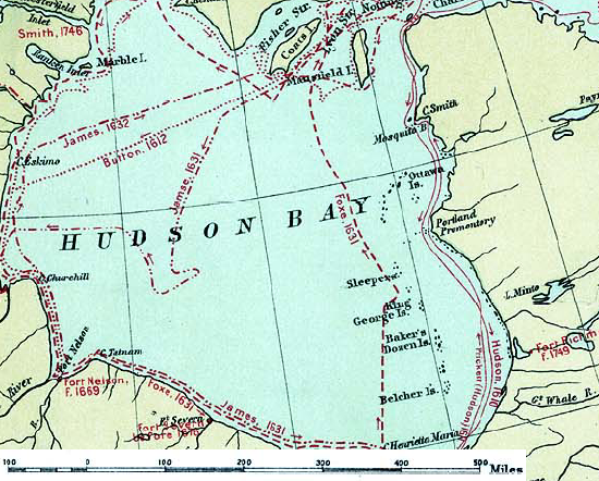
English: Map of the routes of the main European explorers in Hudson Bay, Canada. |
|||||
| Дата | ||||||
| Източник | Excerpted from 1st Edition, 1906, Atlas of Canada - Routes of Explorers,1497 to 1905. | |||||
| Автор | Department of the Interior, Ottawa | |||||
| Права (Повторно използване на файла) |
Crown copyright expired.
|

Дневник на оригиналното качване
- 2007-01-26 22:28 CyclePat 550×442×8 (459278 bytes) ==Description== This map shows the routes followed by the principal explorers of what is now Canada, from 1497 up to 1905. The map also shows the location of forts with the date of their establishment. It was created using [[:image:Canada, Routes of Explo
История на файла
Избирането на дата/час ще покаже как е изглеждал файлът към онзи момент.
| Дата/Час | Миникартинка | Размер | Потребител | Коментар | |
|---|---|---|---|---|---|
| текуща | 11:41, 10 юли 2008 | | 550 × 442 (449 КБ) | Urdangaray | {{Information |Description={{en|thumb|400px|right|Canada, Routes of Explorers,1497 to 1905 This map shows the routes followed by the principal explorers of what is now Canada, from 1497 up to 190 |
Използване на файла
Следната страница използва следния файл:
Глобално използване на файл
Този файл се използва от следните други уикита:
- Употреба в ast.wikipedia.org
- Употреба в az.wikipedia.org
- Употреба в ca.wikipedia.org
- Употреба в cv.wikipedia.org
- Употреба в de.wikipedia.org
- Употреба в en.wikipedia.org
- Употреба в es.wikipedia.org
- Употреба в hi.wikipedia.org
- Употреба в nn.wikipedia.org
- Употреба в ru.wikipedia.org
- Употреба в zh.wikipedia.org