Файл:Illyricum & Dacia - AD 400.png

Размер на този преглед: 800 × 554 пиксела. Други разделителни способности: 320 × 222 пиксела | 640 × 444 пиксела | 971 × 673 пиксела.
Оригинален файл (971 × 673 пиксела, големина на файла: 972 КБ, MIME-тип: image/png)
| Този файл е от Общомедия и може да се използва от други проекти.
Следва информация за файла, достъпна през оригиналната му описателна страница. |
Резюме
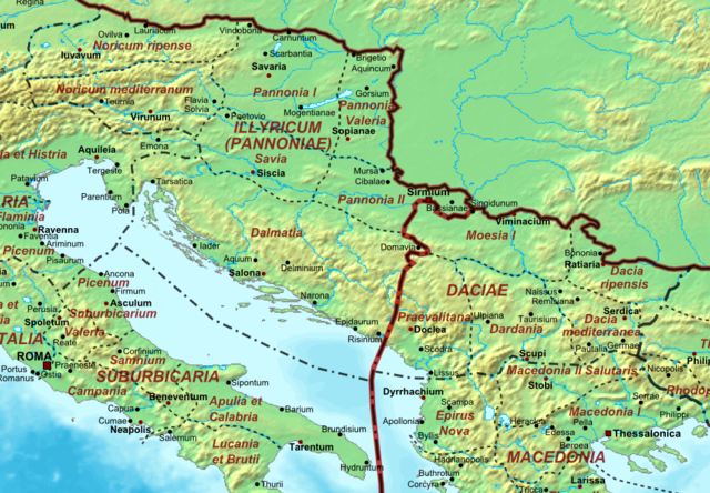
| Описание | Map of the Roman Empire ca. 400 AD, showing the administrative division into dioceses and provinces, as well as the major cities. The demarcation between Eastern and Western Empires is noted in red. |
| Дата | (UTC) |
| Източник |
This file was derived from: The Roman Empire ca 400 AD.png: |
| Автор |
|
| This is a retouched picture, which means that it has been digitally altered from its original version. Modifications: Illyricum and Dacia. The original can be viewed here: The Roman Empire ca 400 AD.png:
|
Лицензиране
Аз, носителят на авторските права над тази творба, я публикувам тук под следния лиценз:
| Аз, носителят на авторските права над тази творба, я публикувам като обществено достояние. Това разрешение е в сила за целия свят. В някои държави това може да не е възможно от законодателна гледна точка; затова: Давам на всекиго правото да използва тази творба за всякакви цели, без никакви условия, освен ако такива условия съществуват по закон. |
Дневник на оригиналното качване
This image is a derivative work of the following images:
- File:The_Roman_Empire_ca_400_AD.png licensed with PD-self
- 2011-07-21T13:03:22Z Cplakidas 4339x2689 (11429663 Bytes) fixed Persian border, differentiated between Eastern and Western empire, different borders for praet. prefectures
- 2009-03-21T02:37:17Z Cplakidas 4475x2600 (10476876 Bytes) minor corrections
- 2008-05-29T12:30:03Z Cplakidas 3800x2370 (8491181 Bytes)
- 2008-05-29T12:17:05Z Cplakidas 4560x2850 (11764337 Bytes) clearer version & addition of the Armenian satrapies
- 2007-12-30T02:02:48Z Cplakidas 3380x2120 (6247724 Bytes) added names of dioceses, legend box, various minor adjustments
- 2007-12-13T14:27:35Z Cplakidas 3550x2200 (6970232 Bytes) new improved version made with Inkscape, slight corrections in borders, added several cities in Africa & Spain
- 2007-11-12T19:27:37Z Cplakidas 3550x2200 (4979411 Bytes) minor corrections in southern Gaul
- 2007-11-05T12:58:04Z Cplakidas 3550x2200 (4977196 Bytes) New version, with some corrections & additions
- 2007-10-31T16:55:48Z Cplakidas 3436x2142 (4722554 Bytes) {{Information |Description=Map of the [[Roman Empire]] ca. 400 AD, showing the administrative division into dioceses and provinces, as well as the major cities. The demarcation between Eastern and Western Empires is noted in
Uploaded with derivativeFX
История на файла
Избирането на дата/час ще покаже как е изглеждал файлът към онзи момент.
| Дата/Час | Миникартинка | Размер | Потребител | Коментар | |
|---|---|---|---|---|---|
| текуща | 21:27, 22 декември 2013 | | 971 × 673 (972 КБ) | Jbribeiro1 | == {{int:filedesc}} == {{Information |Description=Map of the Roman Empire ca. 400 AD, showing the administrative division into dioceses and provinces, as well as the major cities. The demarcation between Eastern and Western Empires is noted in red.... |
Използване на файла
Следните 2 страници използват следния файл:
Глобално използване на файл
Този файл се използва от следните други уикита:
- Употреба в ar.wikipedia.org
- Употреба в ca.wikipedia.org
- Употреба в de.wikipedia.org
- Употреба в el.wikipedia.org
- Употреба в en.wikipedia.org
- Употреба в es.wikipedia.org
- Употреба в fr.wikipedia.org
- Употреба в hr.wikipedia.org
- Употреба в lt.wikipedia.org
- Употреба в pl.wikipedia.org
- Употреба в pt.wikipedia.org
- Употреба в ro.wikipedia.org
- Употреба в sr.wikipedia.org
- Употреба в tr.wikipedia.org
- Употреба в www.wikidata.org