Файл:Lake Athabasca, Canada.jpg

Размер на този преглед: 800 × 338 пиксела. Други разделителни способности: 320 × 135 пиксела | 640 × 270 пиксела | 1156 × 488 пиксела.
Оригинален файл (1156 × 488 пиксела, големина на файла: 173 КБ, MIME-тип: image/jpeg)
| Този файл е от Общомедия и може да се използва от други проекти.
Следва информация за файла, достъпна през оригиналната му описателна страница. |
Резюме
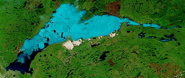
| Описание | Lake Athabasca, Canada. Lake Athabasca straddles the border between Alberta (west) and Saskatchewan (east) - the black line. In the false-color image, vegetation is green, water is dark blue, and ice (or snow) is light blue. |
| Дата | Visualization Date: 2002-06-18 |
| Източник | Visible Earth, NASA (extract) |
| Автор | Jacques Descloitres, MODIS Land Rapid Response Team, NASA/GSFC |
Cropped from the original 4800 x 3600 JPEG (4.4MB) image.
Лицензиране
| This file is in the public domain in the United States because it was solely created by NASA. NASA copyright policy states that "NASA material is not protected by copyright unless noted". (See Template:PD-USGov, NASA copyright policy page or JPL Image Use Policy.) | ||
 |
Warnings:
|
История на файла
Избирането на дата/час ще покаже как е изглеждал файлът към онзи момент.
| Дата/Час | Миникартинка | Размер | Потребител | Коментар | |
|---|---|---|---|---|---|
| текуща | 11:37, 18 август 2006 | | 1156 × 488 (173 КБ) | Feydey | {{Information |Description= Lake Athabasca, Canada. Lake Athabasca straddles the border between Alberta (west) and Saskatchewan (east) - the black line. In the false-color image, vegetation is green, water is dark blue, and ice (or snow) is light blue. |S |
Използване на файла
Следната страница използва следния файл:
Глобално използване на файл
Този файл се използва от следните други уикита:
- Употреба в af.wikipedia.org
- Употреба в ar.wikipedia.org
- Употреба в arz.wikipedia.org
- Употреба в be.wikipedia.org
- Употреба в bn.wikipedia.org
- Употреба в bs.wikipedia.org
- Употреба в ca.wikipedia.org
- Употреба в ceb.wikipedia.org
- Употреба в cv.wikipedia.org
- Употреба в cy.wikipedia.org
- Употреба в da.wikipedia.org
- Употреба в el.wikipedia.org
- Употреба в en.wikipedia.org
- Употреба в eo.wikipedia.org
- Употреба в es.wikipedia.org
- Употреба в eu.wikipedia.org
- Употреба в fa.wikipedia.org
- Употреба в frr.wikipedia.org
- Употреба в fr.wikipedia.org
- Употреба в fy.wikipedia.org
- Употреба в hu.wikipedia.org
- Употреба в hy.wikipedia.org
- Употреба в id.wikipedia.org
- Употреба в incubator.wikimedia.org
- Употреба в it.wikipedia.org
- Употреба в ka.wikipedia.org
- Употреба в kk.wikipedia.org
- Употреба в ky.wikipedia.org
- Употреба в lt.wikipedia.org
- Употреба в lv.wikipedia.org
- Употреба в nl.wikipedia.org
- Употреба в no.wikipedia.org
- Употреба в pl.wikipedia.org
- Употреба в pl.wiktionary.org
- Употреба в pnb.wikipedia.org
- Употреба в pt.wikipedia.org
- Употреба в ro.wikipedia.org
- Употреба в ru.wikipedia.org
- Употреба в sv.wikipedia.org
Преглед на глобалната употреба на файла.