Файл:Madhhab Map2.png
Размер на този преглед: 800 × 388 пиксела. Други разделителни способности: 320 × 155 пиксела | 640 × 310 пиксела | 1245 × 604 пиксела.
Оригинален файл (1245 × 604 пиксела, големина на файла: 50 КБ, MIME-тип: image/png)
| Този файл е от Общомедия и може да се използва от други проекти.
Следва информация за файла, достъпна през оригиналната му описателна страница. |

|
Това изображение (или всички изображения в тази страница/категория) би трябвало да бъдат пресъздадени с използване на векторна графика във формат SVG. Това има няколко предимства; вижте Commons:Media for cleanup за повече информация. Ако разполагате с това избражение в SVG формат, моля качете го. След това заместете този шаблон с {{Vector version available|име на новия файл.svg}}.
|
Резюме
| Описание |
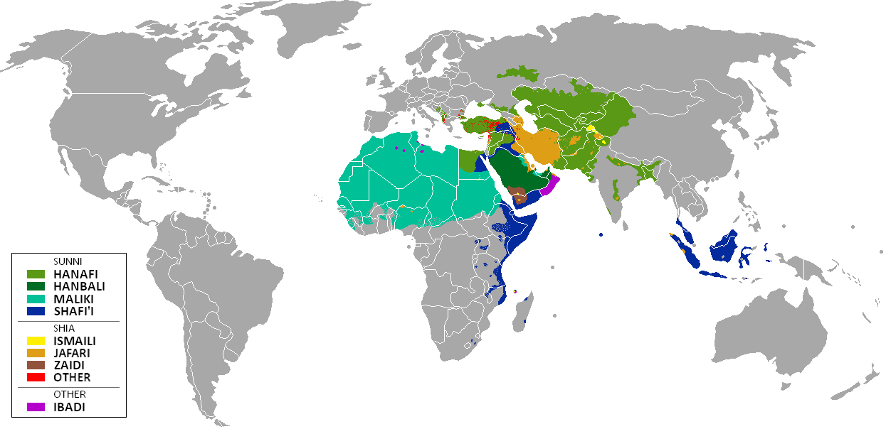
العربية: المدارس الفقهية الإسلامية الرئيسيّة وانتشارها حول العالم (لغة إنجليزية)
فارسی: نقشهٔ پراکندگی مذاهب فقهی اسلام در جهان (انگلیسی)
English: The distribution of the predominant Islamic madhhab (school of law) followed in majority-Muslim countries and regions (English)
Bahasa Indonesia: Distribusi penyebaran agama islam berdasarkan Mahdab di negara-negara dan wilayah dunia |
| Дата | |
| Източник | Own work by uploader from a blank-map, based on this source: Legal Sources and various other sources |
| Автор | Ghibar |
| други версии |
Derivative works of this file: |
Лицензиране
Аз, носителят на авторските права над тази творба, я публикувам тук под следните лицензи:
Този файл се разпространява под лиценз Криейтив Комънс Признание — Споделяне на споделеното 3.0.
- Можете свободно:
- да споделяте – да копирате, разпространявате и излъчвате произведението
- да ремиксирате – да адаптирате произведението
- Съгласно следните условия:
- признание на авторството – Трябва да посочите авторството, да добавите връзка към лиценза и да посочите дали са правени промени. Можете да направите това по всякакъв разумен начин, но не и по начин, оставящ впечатлението, че същият/същите подкрепят вас или използването по някакъв начин на творбата от вас.
- споделяне на споделеното – В случай, че промените, видоизмените или използвайки като основа произведението, го надградите, то полученото производно произведение може да се разпространява само съгласно условията на същия или съвместим лиценз с оригиналния такъв.

|
Предоставя се разрешение за копиране, разпространение и/или модификация на този документ според Лиценза за свободна документация на ГНУ, в своята версия 1.2 или някоя следваща версия, издадена от Фондацията за свободен софтуер; без непроменими раздели, без текст на предната подвързия и без текст на задната подвързия. Копие на този лиценз е приложено в раздела Лиценз за свободна документация на ГНУ. |
Можете да изберете лиценз по Ваш избор.
| Annotations | This image is annotated: View the annotations at Commons |
История на файла
Избирането на дата/час ще покаже как е изглеждал файлът към онзи момент.
| Дата/Час | Миникартинка | Размер | Потребител | Коментар | |
|---|---|---|---|---|---|
| текуща | 11:24, 23 януари 2018 | | 1245 × 604 (50 КБ) | Maphobbyist | Revert. Jafari school more widespread in northern Sumatra according to sources, than mere dots. |
| 11:55, 30 май 2016 |  | 1245 × 604 (2,87 МБ) | Riyantojayadi | Madhhab majority of Aceh region[1] and West Sumatra/Minangkabau region[2] in Indonesia are Syafii school of Sunni. There are some tribe's ritual in this area that are based on Shia such tabot, however, for religion, they are practicing . Shia communiti... | |
| 13:45, 11 януари 2015 |  | 1245 × 604 (50 КБ) | AnonMoos | Reverted to version as of 02:11, 30 July 2014 -- see User_talk:Peaceworld111 | |
| 10:24, 11 януари 2015 |  | 1245 × 604 (52 КБ) | Peaceworld111 | Re-added Ahmadi. It's a sect of Islam per reliable sources and is not a mere dot. See talk page. | |
| 02:10, 11 януари 2015 |  | 1245 × 604 (50 КБ) | AnonMoos | Reverted to version as of 02:11, 30 July 2014 -- change not discussed on image talk page, possibly problematic, see user talk page | |
| 18:11, 8 януари 2015 |  | 1245 × 604 (52 КБ) | Peaceworld111 | Added Ahmadi | |
| 02:11, 30 юли 2014 |  | 1245 × 604 (50 КБ) | KronosLine | Fixed Russia | |
| 18:36, 20 юли 2014 |  | 1245 × 604 (63 КБ) | Calthinus | distribution of Bektashis in Albania fixed, distribution of Muslims in Greece & Macedonia (esp the ethnic Slav Macedonian Muslims, whose distribution had previously not been marked) fixed, various other fixes... | |
| 17:50, 19 октомври 2013 |  | 1245 × 604 (50 КБ) | Hibernian | Damn it, that revert button doesn't do what I thought it does. Here's what I meant to change it to. This version also changes the Kerala Muslims to Shafi'i as was suggested on the talk page. | |
| 17:37, 19 октомври 2013 |  | 1245 × 604 (55 КБ) | Hibernian | Reverted to previous version. It is totally illogical to not show the borders of states with limited recognition (practically every map on Wikipedia depicts these entities), it has nothing to do with the official UN definitions, but with showing reality. |
Използване на файла
Няма страници, използващи файла.
Глобално използване на файл
Този файл се използва от следните други уикита:
- Употреба в bn.wikipedia.org
- Употреба в bn.wikivoyage.org
- Употреба в en.wikipedia.org
- Употреба в en.wikivoyage.org
- Употреба в he.wikipedia.org
- Употреба в hi.wikivoyage.org
- Употреба в id.wikipedia.org
- Употреба в incubator.wikimedia.org
- Употреба в it.wikivoyage.org
- Употреба в ja.wikipedia.org
- Употреба в mzn.wikipedia.org
- Употреба в uk.wikipedia.org