Файл:Mazowieckie mapa fizyczna.png

Размер на този преглед: 579 × 600 пиксела. Други разделителни способности: 232 × 240 пиксела | 463 × 480 пиксела | 741 × 768 пиксела | 988 × 1024 пиксела | 1977 × 2048 пиксела | 3120 × 3232 пиксела.
Оригинален файл (3120 × 3232 пиксела, големина на файла: 940 КБ, MIME-тип: image/png)
| Този файл е от Общомедия и може да се използва от други проекти.
Следва информация за файла, достъпна през оригиналната му описателна страница. |
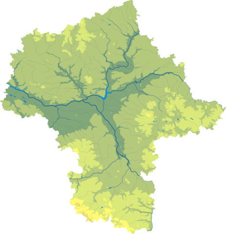
| Описание |
Polski: Mapa wód i ukształtowania powierzchni województwa opolskiego mazowieckiego.
Współrzędne graniczne mapy:
English: Relief map of Masovian Voivodeship. |
||
| Дата | |||
| Източник | Mazowieckie mapa fizyczna, which was created and published under GFDL-self by Aotearoa. | ||
| Автор | Aotearoa | ||
| Права (Повторно използване на файла) |
|

Legend

История на файла
Избирането на дата/час ще покаже как е изглеждал файлът към онзи момент.
| Дата/Час | Миникартинка | Размер | Потребител | Коментар | |
|---|---|---|---|---|---|
| текуща | 10:43, 29 октомври 2012 | | 3120 × 3232 (940 КБ) | Aotearoa | drobne techniczne |
| 02:51, 12 февруари 2007 |  | 637 × 657 (121 КБ) | Bonas | {{Information |Description= Relief map of Masovian Voivodeship. |Source= Mazowieckie mapa fizyczna, which was created and published under GFDL-self by [[:pl:Wikipedysta:Aotearoa|A |
Използване на файла
Следните 66 страници използват следния файл:
- Белск Дужи
- Бялобжеги
- Варшава
- Венгров
- Вишков
- Водине
- Воломин
- Вулка Косовска
- Гарволин
- Гостинин
- Гроджиск Мазовецки
- Груйец
- Гура Калвария
- Джержаново Осада
- Дзежгово
- Дробин
- Жельонка (Воломински окръг)
- Желязова Воля
- Жирардов
- Журомин
- Залеше Гурне
- Зволен (Полша)
- Зомбки
- Йедълня-Летниско
- Кобилка
- Коженице
- Констанчин-Йежьорна
- Легьоново
- Липско
- Ломянки
- Лошице
- Маков Мазовецки
- Марки
- Миляновек
- Минск Мазовецки
- Млава (град)
- Мокободи
- Мшчонов
- Нови Двур Мазовецки
- Ожаров Мазовецки
- Остров Мазовецка
- Остроленка
- Отвоцк
- Петъровице
- Плонск
- Плоцк
- Прушков
- Пултуск
- Пшасниш
- Пшисуха
- Пьонки
- Пясечно
- Пястов
- Радом
- Соколов Подляски
- Сохачев
- Стар град във Варшава
- Сулейовек
- Трояни (Мазовско войводство)
- Тчув
- Чеханов
- Шедълце
- Шерпц
- Шидловец
- Янки (Полша)
- Шаблон:ПК Полша Мазовско войводство
Глобално използване на файл
Този файл се използва от следните други уикита:
- Употреба в be-tarask.wikipedia.org
- Употреба в be.wikipedia.org
- Употреба в ce.wikipedia.org
- Употреба в de.wikipedia.org
- Употреба в hsb.wikipedia.org
- Употреба в hu.wikipedia.org
- Употреба в lt.wikipedia.org
- Употреба в lv.wikipedia.org
- Употреба в pl.wikipedia.org
- Употреба в pt.wikipedia.org
- Употреба в ru.wikipedia.org
- Употреба в uk.wikipedia.org
- Употреба в www.wikidata.org