Файл:Nile River Delta at Night.JPG

Оригинален файл (4256 × 2832 пиксела, големина на файла: 2,05 МБ, MIME-тип: image/jpeg)
| Този файл е от Общомедия и може да се използва от други проекти.
Следва информация за файла, достъпна през оригиналната му описателна страница. |
Резюме
| Описание |
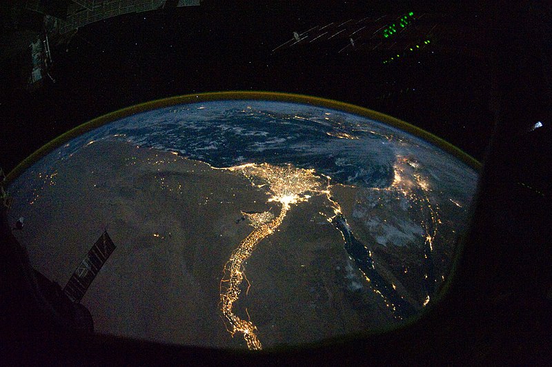
English: In this view of Egypt, we see a population almost completely concentrated along the Nile Valley, just a small percentage of the country’s land area. The Nile River and its delta look like a brilliant, long-stemmed flower in this astronaut photograph of the south-eastern Mediterranean Sea, as seen from the International Space Station. The Cairo metropolitan area forms a particularly bright base of the flower. The smaller cities and towns within the Nile Delta tend to be hard to see amidst the dense agricultural vegetation during the day. However, these settled areas and the connecting roads between them become clearly visible at night. Likewise, urbanized regions and infrastructure along the Nile River becomes apparent.
Another brightly lit region is visible along the eastern coastline of the Mediterranean—the Tel-Aviv metropolitan area in Israel (image right). To the east of Tel-Aviv lies Amman, Jordan. The two major water bodies that define the western and eastern coastlines of the Sinai Peninsula—the Gulf of Suez and the Gulf of Aqaba—are outlined by lights along their coastlines (image lower right). The city lights of Paphos, Limassol, Larnaca, and Nicosia are visible on the island of Cyprus (image top). Scattered blue-grey clouds cover the Mediterranean Sea and the Sinai, while much of north-eastern Africa is cloud-free. A thin yellow-brown band tracing the Earth’s curvature at image top is air-glow, a faint band of light emission that results from the interaction of atmospheric atoms and molecules with solar radiation at approximately 100 kilometres altitude. |
| Дата | |
| Източник | NASA Earth Observatory |
| Автор | ISS Expedition 25 crew |
| други версии |
Derivative works of this file: Nile River Delta at Night cropped.JPG Also see http://earthobservatory.nasa.gov/IOTD/view.php?id=46820&src=eoa-iotd for annotated version, with features identified. |
| Camera location | | View this and other nearby images on: OpenStreetMap |
|---|
Тази картинка е каталогизирина от Космическия център „Джонсън“ към НАСА с идентификационен номер (Photo ID): ISS025-E-9858. Този етикет не посочва статуса около авторското право към прикачената творба. Изисква се нормален етикет за авторско право. Вижте Общомедия:Лицензиране за повече информация. Други езици:
|
Image acquired with a Nikon D3S digital camera using a 16 mm lens, and is provided by the ISS Crew Earth Observations experiment and Image Science & Analysis Laboratory, Johnson Space Center.
Лицензиране
| This file is in the public domain in the United States because it was solely created by NASA. NASA copyright policy states that "NASA material is not protected by copyright unless noted". (See Template:PD-USGov, NASA copyright policy page or JPL Image Use Policy.) | ||
 |
Warnings:
|
| Annotations | This image is annotated: View the annotations at Commons |
История на файла
Избирането на дата/час ще покаже как е изглеждал файлът към онзи момент.
| Дата/Час | Миникартинка | Размер | Потребител | Коментар | |
|---|---|---|---|---|---|
| текуща | 12:51, 8 ноември 2010 | | 4256 × 2832 (2,05 МБ) | Originalwana | {{Information |Description={{en|1=In this view of Egypt, we see a population almost completely concentrated along the Nile Valley, just a small percentage of the country’s land area. The Nile River and its delta look like a brilliant, long-stemmed flow |
Използване на файла
Следната страница използва следния файл:
Глобално използване на файл
Този файл се използва от следните други уикита:
- Употреба в af.wikipedia.org
- Употреба в arz.wikipedia.org
- Употреба в av.wikipedia.org
- Употреба в bs.wikipedia.org
- Употреба в cs.wikipedia.org
- Употреба в el.wikipedia.org
- Употреба в en.wikipedia.org
- Употреба в en.wiktionary.org
- Употреба в es.wikipedia.org
- Употреба в ha.wikipedia.org
- Употреба в he.wikipedia.org
- Употреба в incubator.wikimedia.org
- Употреба в ln.wikipedia.org
- Употреба в ml.wikipedia.org
- Употреба в no.wikipedia.org
- Употреба в sd.wikipedia.org
- Употреба в sk.wikipedia.org
- Употреба в sl.wikipedia.org
- Употреба в sq.wikipedia.org
- Употреба в sq.wikiquote.org
- Употреба в sr.wikipedia.org
- Употреба в sv.wikipedia.org
- Употреба в ta.wikipedia.org
- Употреба в th.wikipedia.org
- Употреба в tr.wikipedia.org
- Употреба в uk.wikipedia.org
- Употреба в ur.wikipedia.org
- Употреба в vi.wikipedia.org