Файл:Nye fylker - regjeringen.no.svg

Оригинален файл (Файл във формат SVG, основен размер: 515 × 689 пиксела, големина на файла: 85 КБ)
| Този файл е от Общомедия и може да се използва от други проекти.
Следва информация за файла, достъпна през оригиналната му описателна страница. |
Резюме
| Описание |
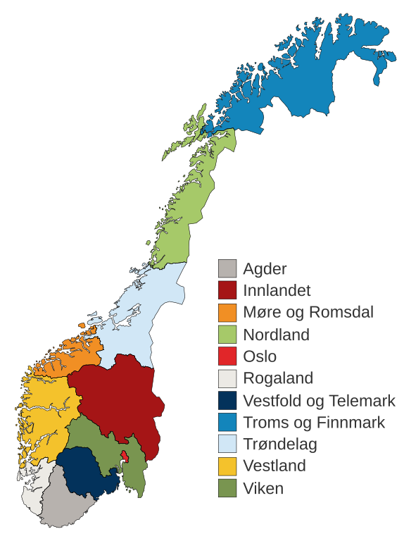
English: Municipal and regional reform: "On 8 June 2017, the Storting decided the following merger of counties". Illustration included.
Norsk bokmål: Kommune- og regionreform: "Stortinget vedtok 8. juni 2017 følgende sammenslåinger av fylker". Medfølgende kart-illustrasjon. |
|||
| Дата | ||||
| Източник |
This file was derived from: Fylkeskart-regionreform.jpg |
|||
| Автор | Furfur | |||
| Права (Повторно използване на файла) |
|
|||
| други версии |
|
|||
| SVG развитие | This map was created with Adobe Illustrator. |


История на файла
Избирането на дата/час ще покаже как е изглеждал файлът към онзи момент.
| Дата/Час | Миникартинка | Размер | Потребител | Коментар | |
|---|---|---|---|---|---|
| текуща | 01:54, 3 януари 2020 | | 515 × 689 (85 КБ) | Furfur | Korr. |
| 01:42, 3 януари 2020 |  | 515 × 689 (85 КБ) | Furfur | == {{int:filedesc}} == {{Information |Description={{User:Medium69/Traduction}} {{no|1=Kommune- og regionreform: "Stortinget vedtok 8. juni 2017 følgende sammenslåinger av fylker". Medfølgende kart-illustrasjon. }} |Source={{Derived from|Fylkeskart-regionreform.jpg}} *[https://www.regjeringen.no/no/tema/kommuner-og-regioner/regionreform/regionreform/nye-fylker/id2548426/ Nye fylker] |Date=2020-01-03 |Author={{U|Furfur}} |Permission={{self|GFDL|cc-by-sa-4.0}} |Other versions={{bva|Fylkeskart-re... |
Използване на файла
Няма страници, използващи файла.
Глобално използване на файл
Този файл се използва от следните други уикита:
- Употреба в bs.wikipedia.org
- Употреба в ca.wikipedia.org
- Употреба в da.wikipedia.org
- Употреба в el.wikipedia.org
- Употреба в en.wikipedia.org
- Употреба в es.wikipedia.org
- Употреба в fa.wikipedia.org
- Употреба в fi.wikipedia.org
- Употреба в he.wikipedia.org
- Употреба в hu.wikipedia.org
- Употреба в is.wikipedia.org
- Употреба в it.wikipedia.org
- Употреба в jv.wikipedia.org
- Употреба в ko.wikipedia.org
- Употреба в nl.wikipedia.org
- Употреба в nn.wikipedia.org
Преглед на глобалната употреба на файла.