Файл:Ocean currents 1943 (borderless)3.png

Размер на този преглед: 800 × 405 пиксела. Други разделителни способности: 320 × 162 пиксела | 640 × 324 пиксела | 1024 × 519 пиксела | 1280 × 649 пиксела | 2577 × 1306 пиксела.
Оригинален файл (2577 × 1306 пиксела, големина на файла: 2,41 МБ, MIME-тип: image/png)
| Този файл е от Общомедия и може да се използва от други проекти.
Следва информация за файла, достъпна през оригиналната му описателна страница. |

|
Това изображение (или всички изображения в тази страница/категория) би трябвало да бъдат пресъздадени с използване на векторна графика във формат SVG. Това има няколко предимства; вижте Commons:Media for cleanup за повече информация. Ако разполагате с това избражение в SVG формат, моля качете го. След това заместете този шаблон с {{Vector version available|име на новия файл.svg}}.
|
Резюме
| Описание |
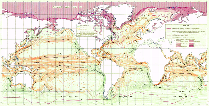
English: Ocean Currents and Sea Ice from Atlas of World Maps, United States Army Service Forces, Army Specialized Training Division. Army Service Forces Manual M-101 (1943).
Türkçe: Dünyanın büyük akıntılarının şeması |
|||
| Дата | ||||
| Източник | Edited version of File:Ocean currents 1943 (borderless).png | |||
| Автор | US army | |||
| Права (Повторно използване на файла) |
|
|||
| други версии |
This file was derived from: Ocean currents 1943 (borderless).png (For more versions see there) |

.png)
3.png)
.png)
| This is a retouched picture, which means that it has been digitally altered from its original version. Modifications: landmass interiors clarified, some latitude and longitude lines repaired, bottom longitudinal numbering replaced, and a stray pencil mark through the Indian Ocean removed. The original can be viewed here: Ocean currents 1943 (borderless).png:
|
Assessment
|
3.png)
История на файла
Избирането на дата/час ще покаже как е изглеждал файлът към онзи момент.
| Дата/Час | Миникартинка | Размер | Потребител | Коментар | |
|---|---|---|---|---|---|
| текуща | 21:18, 2 февруари 2012 | | 2577 × 1306 (2,41 МБ) | Mahahahaneapneap | Compressed again. Please don't revert unless you can give a reason why. |
| 21:48, 19 януари 2012 |  | 2577 × 1306 (3,4 МБ) | The ed17 | there is no reason to compress this | |
| 18:27, 24 декември 2011 |  | 2577 × 1306 (2,41 МБ) | Mahahahaneapneap | Compressed. Identical image, 1 MB smaller. | |
| 14:34, 4 септември 2009 |  | 2577 × 1306 (3,4 МБ) | Durova | Reverted to version as of 08:15, 27 June 2008 reverting arbitrary compression | |
| 20:54, 17 октомври 2008 |  | 2577 × 1306 (2,41 МБ) | Mahahahaneapneap | Compressed | |
| 08:15, 27 юни 2008 |  | 2577 × 1306 (3,4 МБ) | Durova | {{Information |Description=''Ocean Currents and Sea Ice from Atlas of World Maps'', United States Army Service Forces, Army Specialized Training Division. Army Service Forces Manual M-101 (1943). |Source=http://www.lib.utexas.edu/maps/world_maps/ocean |
Използване на файла
Следната страница използва следния файл:
Глобално използване на файл
Този файл се използва от следните други уикита:
- Употреба в ar.wikipedia.org
- Употреба в ast.wikipedia.org
- Употреба в az.wikipedia.org
- Употреба в be.wikipedia.org
- Употреба в bn.wikipedia.org
- Употреба в ca.wikipedia.org
- Употреба в da.wikipedia.org
- Употреба в el.wikipedia.org
- Употреба в en.wikipedia.org
- Ocean current
- Portal:Maps/Selected picture
- History of navigation
- Wikipedia:Featured pictures thumbs/12
- Wikipedia:Featured pictures/Diagrams, drawings, and maps/Maps
- User:Shoemaker's Holiday
- Wikipedia:Featured picture candidates/File:Ocean currents 1943 (borderless)3.png
- Wikipedia:Featured picture candidates/July-2008
- Wikipedia:Wikipedia Signpost/2008-07-07/Features and admins
- User talk:Durova/Archive 60
- Wikipedia:Wikipedia Signpost/2008-08-25/Features and admins
- Wikipedia:Wikipedia Signpost/2008-08-25/SPV
- Wikipedia:Wikipedia Signpost/2008-07-07/SPV
- Portal:Maps/Selected picture/37
- User talk:Shoemaker's Holiday/Archive 2
- Flow map
- Wikipedia:Picture of the day/January 2009
- Template:POTD/2009-01-05
- User talk:Durova/Archive 64
- User:Adam Cuerden
- User:Durova/Featured picture gallery/2008
- Wikipedia:WikiProject United States/Recognized content
- Wikipedia:WikiProject United States/Quality content
- Wikipedia:WikiProject United States/Featured pictures
- Wikipedia:Wikipedia Signpost/Single/2008-07-07
- Wikipedia:Wikipedia Signpost/Single/2008-08-25
- Употреба в es.wikipedia.org
- Употреба в fa.wikipedia.org
- Употреба в hi.wikipedia.org
- Употреба в hu.wikipedia.org
- Употреба в ka.wikipedia.org
- Употреба в lv.wikipedia.org
- Употреба в mr.wikipedia.org
- Употреба в oc.wikipedia.org
- Употреба в pl.wikipedia.org
3.png)
Преглед на глобалната употреба на файла.
3.png)
3.png)