Файл:PIA01153.jpg
Размер на този преглед: 798 × 133 пиксела. Други разделителни способности: 320 × 53 пиксела | 640 × 107 пиксела | 4201 × 701 пиксела.
Оригинален файл (4201 × 701 пиксела, големина на файла: 817 КБ, MIME-тип: image/jpeg)
| Този файл е от Общомедия и може да се използва от други проекти.
Следва информация за файла, достъпна през оригиналната му описателна страница. |
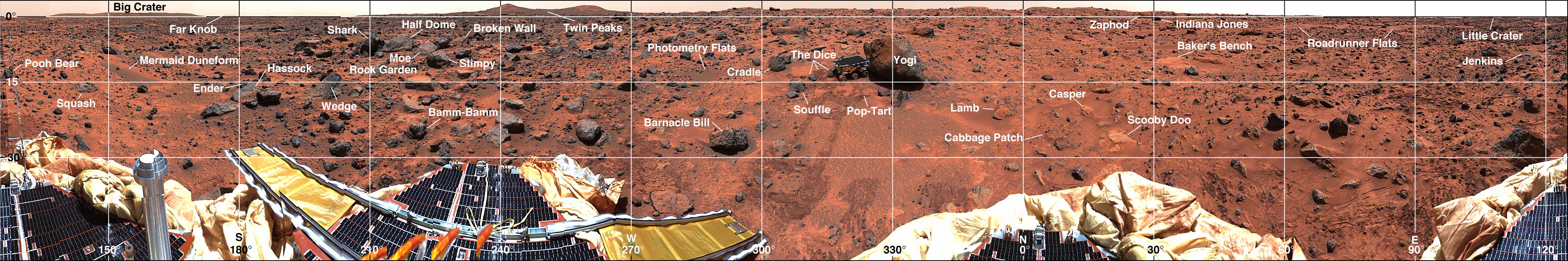
| Описание | Mars-local-level (LL frame) coordinate map of rocks counted at the Mars Pathfinder landing site. Positions, apparent diameters (D), and heights (H) were measured to the nearest centimeter in the Mars map virtual reality environment constructed from the "Monster Pan" |
| Източник | https://photojournal.jpl.nasa.gov/catalog/PIA01153 |
| Автор | NASA |
| Права (Повторно използване на файла) |
Original work of NASA - public domain |
| други версии | http://photojournal.jpl.nasa.gov/catalog/PIA01153 |
| This file is in the public domain in the United States because it was solely created by NASA. NASA copyright policy states that "NASA material is not protected by copyright unless noted". (See Template:PD-USGov, NASA copyright policy page or JPL Image Use Policy.) | ||
 |
Warnings:
|
История на файла
Избирането на дата/час ще покаже как е изглеждал файлът към онзи момент.
| Дата/Час | Миникартинка | Размер | Потребител | Коментар | |
|---|---|---|---|---|---|
| текуща | 18:33, 27 май 2007 | 4201 × 701 (817 КБ) | Clh288~commonswiki | {{Information |Description= Mars-local-level (LL frame) coordinate map of rocks counted at the Mars Pathfinder landing site. Positions, apparent diameters (D), and heights (H) were measured to the nearest centimeter in the Mars map virtual reality envi |
Използване на файла
Следната страница използва следния файл:
Глобално използване на файл
Този файл се използва от следните други уикита:
- Употреба в be.wikipedia.org
- Употреба в en.wikipedia.org
- Употреба в ru.wikipedia.org
- Употреба в uk.wikipedia.org
- Употреба в zh.wikipedia.org