Файл:Pont du Gard BLS.jpg

Размер на този преглед: 800 × 309 пиксела. Други разделителни способности: 320 × 124 пиксела | 640 × 247 пиксела | 1024 × 395 пиксела | 1280 × 494 пиксела | 2560 × 988 пиксела | 12 648 × 4882 пиксела.
Оригинален файл (12 648 × 4882 пиксела, големина на файла: 18,75 МБ, MIME-тип: image/jpeg)
| Този файл е от Общомедия и може да се използва от други проекти.
Следва информация за файла, достъпна през оригиналната му описателна страница. |
|
Резюме
| Описание |
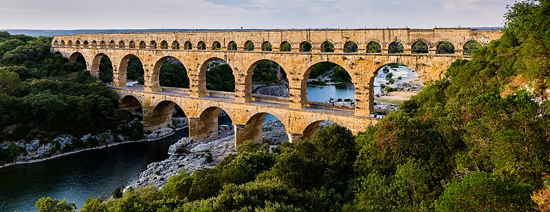
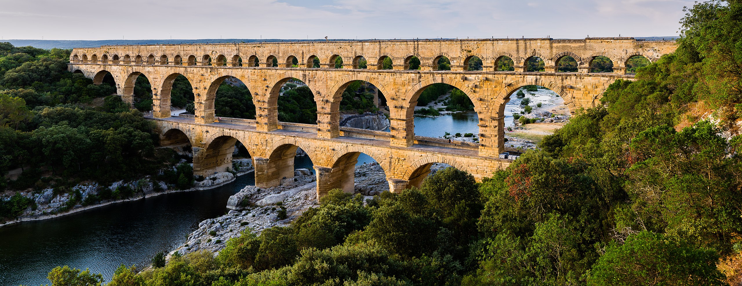
English: Pont du Gard, in Vers-Pont-du-Gard, Gard department, South France. The Pont du Gard is the most famous part of the roman aqueduct which carried water from Uzès to Nîmes until roughly the 9th century when maintenance was abandoned. The monument is 49m high and now 275m long (it was 360m when intact) at its top. It's the highest roman aqueduct, but also one of the best preserved (with the aqueduct of Segovia). The Pont du Gard has been a UNESCO world heritage site since 1985.
Français : Le Pont du Gard, à Vers-Pont-du-Gard, département du Gard, région Languedoc-Roussillon, France. Le Pont du Gard (1er siècle C.E.) est la partie la plus célèbre de l'aqueduc romain qui conduisait l'eau d'Uzès à Nîmes, jusqu'au 9ème siècle où l'on cessa de l'entretenir. Le monument fait 49 mètres de haut et aujourd'hui 275 mètres de long (360 mètres quand il était intact). C'est l'aqueduc roman le plus haut, mais aussi, avec celui de Ségovie, l'un des mieux préservés. Le Pont du Gard est un site du patrimoine mondial de l'humanité de l'UNESCO depuis 1985.
Español: El Pont du Gard (puente del Gard), en Vers-Pont-du-Gard, departamento de Gard, en la región de Languedoc-Rosellón, sur de Francia, es la parte más conocida del acueducto romano que conducía el agua desde Uzès a Nîmes hasta el siglo IX, cuando cesó su actividad. El puente mide 49 metros de alto y 275 metros de largo (360 m cuando se encontraba intacto en la antigüedad). Es el acueducto romano más alto y también, junto al de Segovia, en España, uno de los mejor conservados. El Pont du Gard fue declarado Patrimonio Mundial de la Humanidad por la UNESCO en 1985. |
| Дата | |
| Източник | Pont du Gard |
| Автор | Benh LIEU SONG (Flickr) |
| Camera location | | View this and other nearby images on: OpenStreetMap |
|---|
Лицензиране
Аз, носителят на авторските права над тази творба, я публикувам тук под следния лиценз:
Този файл се разпространява под лиценз Криейтив Комънс Признание — Споделяне на споделеното 3.0.
- Можете свободно:
- да споделяте – да копирате, разпространявате и излъчвате произведението
- да ремиксирате – да адаптирате произведението
- Съгласно следните условия:
- признание на авторството – Трябва да посочите авторството, да добавите връзка към лиценза и да посочите дали са правени промени. Можете да направите това по всякакъв разумен начин, но не и по начин, оставящ впечатлението, че същият/същите подкрепят вас или използването по някакъв начин на творбата от вас.
- споделяне на споделеното – В случай, че промените, видоизмените или използвайки като основа произведението, го надградите, то полученото производно произведение може да се разпространява само съгласно условията на същия или съвместим лиценз с оригиналния такъв.
| Annotations | This image is annotated: View the annotations at Commons |
История на файла
Избирането на дата/час ще покаже как е изглеждал файлът към онзи момент.
| Дата/Час | Миникартинка | Размер | Потребител | Коментар | |
|---|---|---|---|---|---|
| текуща | 17:57, 19 юни 2014 | 12 648 × 4882 (18,75 МБ) | Benh | Verticals. | |
| 10:55, 19 юни 2014 | 12 648 × 4771 (18,78 МБ) | Benh | User created page with UploadWizard |
Използване на файла
Следната страница използва следния файл:
Глобално използване на файл
Този файл се използва от следните други уикита:
- Употреба в af.wikipedia.org
- Употреба в ar.wikipedia.org
- Употреба в ast.wikipedia.org
- Употреба в ban.wikipedia.org
- Употреба в bh.wikipedia.org
- Употреба в bn.wikipedia.org
- Употреба в bn.wikibooks.org
- Употреба в bxr.wikipedia.org
- Употреба в ca.wikipedia.org
- Употреба в ceb.wikipedia.org
- Употреба в cs.wikipedia.org
- Употреба в cy.wikipedia.org
- Употреба в da.wikipedia.org
- Употреба в de.wikipedia.org
- Употреба в de.wikivoyage.org
Преглед на глобалната употреба на файла.