Файл:Population density.png

Размер на този преглед: 800 × 400 пиксела. Други разделителни способности: 320 × 160 пиксела | 640 × 320 пиксела | 1024 × 512 пиксела | 1280 × 640 пиксела | 2560 × 1280 пиксела | 4320 × 2160 пиксела.
Оригинален файл (4320 × 2160 пиксела, големина на файла: 522 КБ, MIME-тип: image/png)
История на файла
Избирането на дата/час ще покаже как е изглеждал файлът към онзи момент.
| Дата/Час | Миникартинка | Размер | Потребител | Коментар | |
|---|---|---|---|---|---|
| текуща | 00:41, 11 април 2013 |  | 4320 × 2160 (522 КБ) | Jahoe | Re-downloaded original from http://eoimages.gsfc.nasa.gov/images/imagerecords/53000/53005/population_density.tif, re-converted to PNG (preserving alpha channel) using tiff2png (by Willem van Schaik and Greg Roelofs). Removed rgb pixel values from fully... |
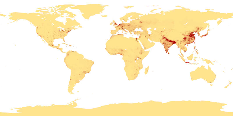
| 03:41, 27 февруари 2007 |  | 4320 × 2160 (915 КБ) | Keenan Pepper | This image shows the number of people per square kilometer around the world in 1994. The data were derived from population records based on political divisions such as states, provinces, and counties. The image was taken from [http://visibleearth.nasa.go |
Използване на файла
Следните 2 страници използват следния файл:
Глобално използване на файл
Този файл се използва от следните други уикита:
- Употреба в als.wikipedia.org
- Употреба в an.wikipedia.org
- Употреба в ar.wikipedia.org
- Употреба в ast.wikipedia.org
- Употреба в az.wikipedia.org
- Употреба в be-tarask.wikipedia.org
- Употреба в be.wikipedia.org
- Употреба в bh.wikipedia.org
- Употреба в bn.wikipedia.org
- Употреба в bs.wikipedia.org
- Употреба в ca.wikipedia.org
- Употреба в ce.wikipedia.org
- Употреба в ckb.wikipedia.org
- Употреба в cu.wikipedia.org
- Употреба в cv.wikipedia.org
- Употреба в da.wikipedia.org
- Употреба в da.wikibooks.org
- Употреба в de.wikipedia.org
- Употреба в dsb.wikipedia.org
- Употреба в el.wikipedia.org
- Употреба в en.wikipedia.org
- Употреба в en.wikiquote.org
- Употреба в eo.wikipedia.org
- Употреба в es.wikipedia.org
Преглед на глобалната употреба на файла.


