Файл:Ptolemaeus Magna Germania.jpg
Размер на този преглед: 800 × 575 пиксела. Други разделителни способности: 320 × 230 пиксела | 640 × 460 пиксела | 1024 × 736 пиксела | 1280 × 920 пиксела | 2560 × 1840 пиксела | 5440 × 3909 пиксела.
Оригинален файл (5440 × 3909 пиксела, големина на файла: 27,13 МБ, MIME-тип: image/jpeg)
| Този файл е от Общомедия и може да се използва от други проекти.
Следва информация за файла, достъпна през оригиналната му описателна страница. |
Резюме
| Описание |
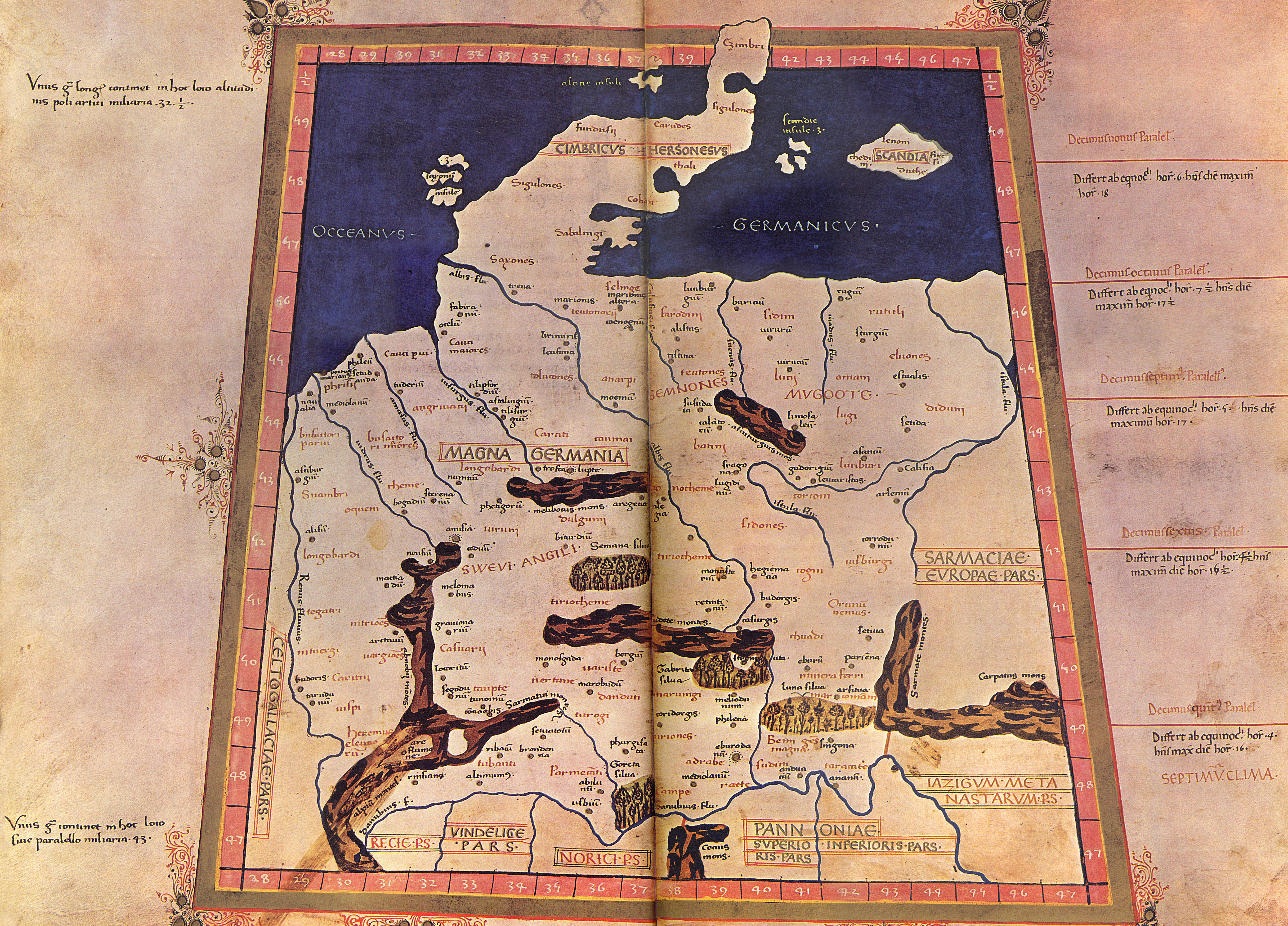
English: The 4th Map of Europe from Ptolemy's Geography, depicting Germany. - The Codex Latinus V. F. 32 is a manuscript edition of Ptolemy's Geography held by the National Library at Naples, Italy. It was photographed for publication in Cosmographia, intro. by Lelio Pagani and photog. by Domenico Lucchetti, in 1975 and 1990. - This is the only map of this Codex currently held in Commons.
Deutsch: EVROPA TABVLA QVARTA – Quarta Europe Tabula continet Germaniam cum insulis sibi adiacentibus. Die Karte zu Magna Germania aus der im Original griechisch verfaßten Geographike Hyphegesis des in Alexandria wirkenden Claudius Ptolemäus (*um 100; † um 175). Spätmittelalterliche Kopie des 15. Jahrhunderts die unter dem Titel Cosmographia erschien. Ptolemäus soll zwischen 125 und 151 tätig gewesen sein. Viele Wissenschaftler gehen davon aus, daß das Kartenwerk entweder vollständig oder zumindest teilweise in späterer Zeit auf der Grundlage des ptolemäischen Textes rekonstruiert worden ist. Der Codex Latinus V F.32 liegt in der Nationalbibliothek Neapel. Das Kartenwerk wird dem in Italien tätigen Deutschen Nicolaus Germanus zugeschrieben. |
||||||||||||||||
| Дата | 15. Jahrhundert/31. Oktober 2009 | ||||||||||||||||
| Източник | Собствена творба | ||||||||||||||||
| Автор |
|
||||||||||||||||
| други версии |
  |
||||||||||||||||
Лицензиране
|
Това произведение е обществено достояние в държавите, в които срокът на авторското право е 100 години или по-малко след смъртта на автора. Това произведение е обществено достояние в Съединените американски щати, защото е било публикувано преди 1 януари 1929 година. | |
| This file has been identified as being free of known restrictions under copyright law, including all related and neighboring rights. | |
История на файла
Избирането на дата/час ще покаже как е изглеждал файлът към онзи момент.
| Дата/Час | Миникартинка | Размер | Потребител | Коментар | |
|---|---|---|---|---|---|
| текуща | 21:20, 31 октомври 2009 | | 5440 × 3909 (27,13 МБ) | Mediatus | {{Information |Description={{de|1=EVROPA TABVLA QVARTA – Quarta Europe Tabula continet Germaniam cum insulis sibi adiacentibus. Die Karte zu ''Magna Germania'' aus der im Original griechisch verfaßten ''Geographike Hyphegesis'' des in Alexandria wirke |
Използване на файла
Следната страница използва следния файл:
Глобално използване на файл
Този файл се използва от следните други уикита:
- Употреба в als.wikipedia.org
- Употреба в ast.wikipedia.org
- Употреба в br.wikipedia.org
- Употреба в ca.wikipedia.org
- Употреба в cs.wikipedia.org
- Употреба в da.wikipedia.org
- Употреба в da.wikibooks.org
- Употреба в de.wikipedia.org
- Artaunon
- Kalisia
- Arae Flaviae
- Germania magna
- Oppidum auf dem Staffelberg
- Leuphana
- Benutzer:Drekamu/Notizen
- Amisia
- Portal Diskussion:Mecklenburg-Vorpommern/Archiv/1
- Treva
- Viadrus
- Benutzer:Mediatus/Bilder
- Gauonarion
- Sousoudata
- Tarodunum
- Wikipedia:WikiProjekt Germanen/Toponymie
- Bikourgion
- Alisus
- Kandounon
- Tropaia Drousou
- Luppia
- Mersouion
- Aregelia
- Loupfourdon
- Karrodounon
- Wikipedia:WikiProjekt Germanen/Projekt
- Segodounon
- Alcimoennis
- Wikipedia:WikiProjekt Germanen
- Rougion
- Siatoutanda
- Fabiranum
- Tekelia
- Lirimeris
- Marionis
- Marionis altera
- Kenennon
- Mounition
- Lakibourgion
- Aitouia
- Ouirition
- Ouirounon
Преглед на глобалната употреба на файла.