Файл:Qinghai lake.jpg

Оригинален файл (640 × 640 пиксела, големина на файла: 138 КБ, MIME-тип: image/jpeg)
| Този файл е от Общомедия и може да се използва от други проекти.
Следва информация за файла, достъпна през оригиналната му описателна страница. |
Резюме
| Описание |
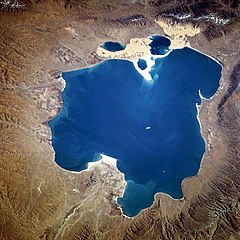
Deutsch: Qinghai-See, China - November 1994
English: Qinghai Lake, China - also, originally known as Koko Nor in Mongolian and Tso Ngonpo in Tibetan - November 1994
Español: Lago Qinghai, China - Noviembre 1994
中文:青海湖 |
|||||
| Дата | Taken on 8 ноември 1994, 04:13:36 GMT | |||||
| Източник |
https://eol.jsc.nasa.gov/sseop/EFS/photoinfo.pl?PHOTO=STS066-118-23 https://eol.jsc.nasa.gov/SearchPhotos/photo.pl?mission=STS066&roll=118&frame=23 |
|||||
| Автор | NASA | |||||
| Права (Повторно използване на файла) |
|
|||||
| NASA information |
|

| Camera location | | View this and other nearby images on: OpenStreetMap |
|---|
Тази картинка е каталогизирина от един от центровете към НАСА с идентификационен номер (Photo ID): STS066-118-23. Този етикет не посочва статуса около авторското право към прикачената творба. Изисква се нормален етикет за авторско право. Вижте Общомедия:Лицензиране за повече информация. Други езици:
|
История на файла
Избирането на дата/час ще покаже как е изглеждал файлът към онзи момент.
| Дата/Час | Миникартинка | Размер | Потребител | Коментар | |
|---|---|---|---|---|---|
| текуща | 15:02, 10 октомври 2005 | | 640 × 640 (138 КБ) | Immanuel Giel | Qinghai Lake, China - November 1994 '''Source''': from the English Wikipedia<br> image description [http://eol.jsc.nasa.gov/sseop/EFS/photoinfo.pl?PHOTO=STS066-118-23 here] en:Qinghai Lake {{PD-USGov-NASA}} |
Използване на файла
Следната страница използва следния файл:
Глобално използване на файл
Този файл се използва от следните други уикита:
- Употреба в ace.wikipedia.org
- Употреба в ar.wikipedia.org
- Употреба в ast.wikipedia.org
- Употреба в az.wikipedia.org
- Употреба в ba.wikipedia.org
- Употреба в be.wikipedia.org
- Употреба в bn.wikipedia.org
- Употреба в bo.wikipedia.org
- Употреба в br.wikipedia.org
- Употреба в ca.wikipedia.org
- Употреба в cdo.wikipedia.org
- Употреба в ceb.wikipedia.org
- Употреба в cs.wikipedia.org
- Употреба в cv.wikipedia.org
- Употреба в da.wikipedia.org
- Употреба в de.wikipedia.org
- Употреба в el.wikipedia.org
- Употреба в en.wikipedia.org
- Употреба в en.wikivoyage.org
- Употреба в eo.wikipedia.org
- Употреба в es.wikipedia.org
Преглед на глобалната употреба на файла.