Файл:Quad Flandria.jpg
Размер на този преглед: 800 × 597 пиксела. Други разделителни способности: 320 × 239 пиксела | 640 × 478 пиксела | 1024 × 765 пиксела | 1280 × 956 пиксела | 2560 × 1912 пиксела | 3345 × 2498 пиксела.
Оригинален файл (3345 × 2498 пиксела, големина на файла: 7,53 МБ, MIME-тип: image/jpeg)
| Този файл е от Общомедия и може да се използва от други проекти.
Следва информация за файла, достъпна през оригиналната му описателна страница. |
Резюме
| Description |
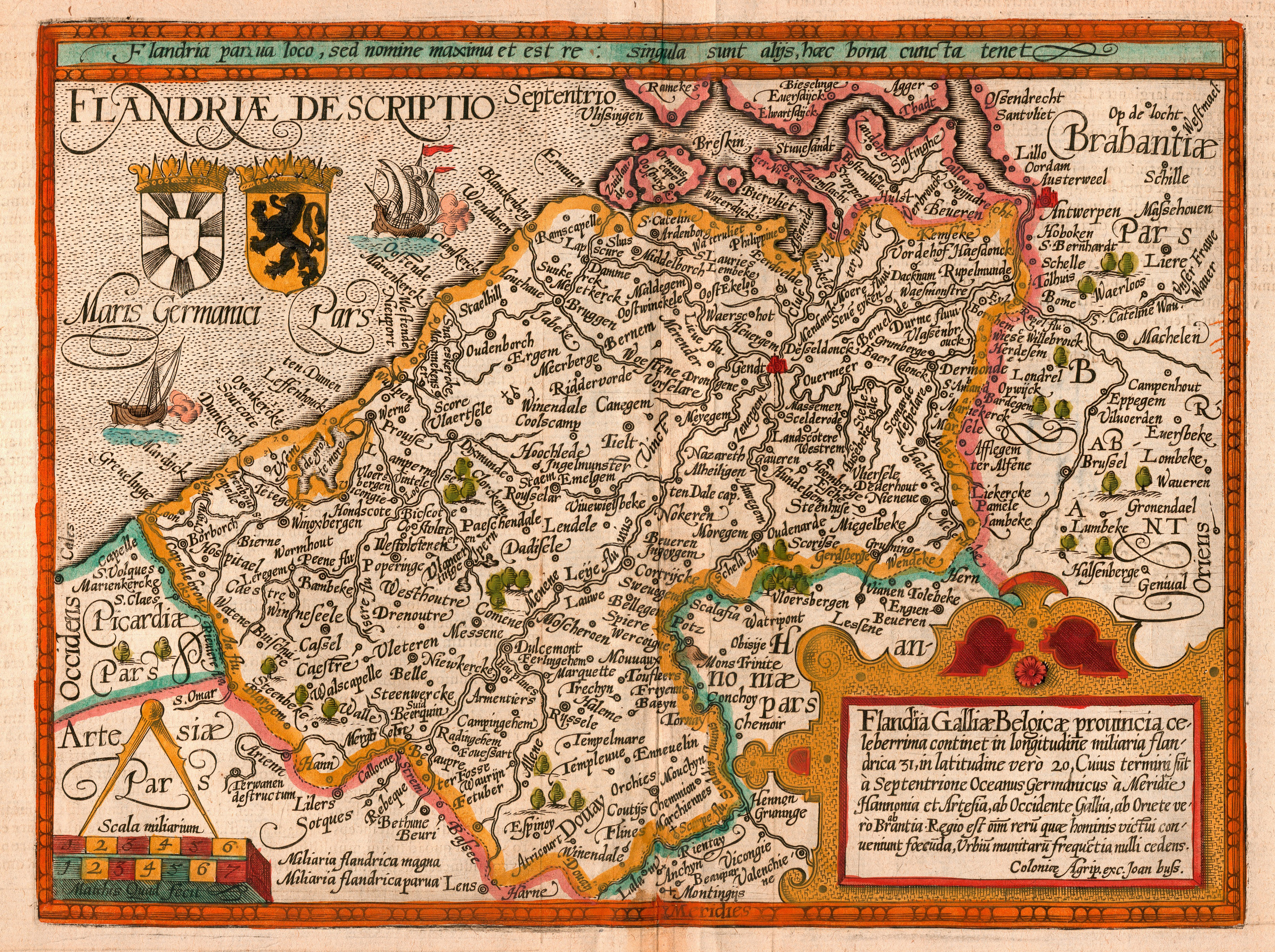
English: Map of the county of Flanders by Matthias Quad (cartographer) and Johannes Bussemacher (engraver & publisher, Cologne)
Nederlands: Kaart van het graafschap Vlaanderen door Matthias Quad (kartograaf) en Johannes Bussemacher (graveur en uitgever, Keulen)
Français : Carte du comté de Flandre par Matthias Quad (cartographe) et Johannes Bussemacher (graveur et éditeur, Cologne)
Español: Mapa del condado de Flandes, de Matthias Quad (cartógrafo) y Johannes Bussemacher (grabador y editor, Colonia, Alemania) |
||||||||||||||||||||||
| Дата | |||||||||||||||||||||||
| Източник | eigen werk (scan) | ||||||||||||||||||||||
| Създател |
scanned by Marc Ryckaert (MJJR) |
||||||||||||||||||||||
| Права (Повторно използване на файла) |
|
||||||||||||||||||||||
| Georeferencing | If inappropriate please set warp_status = skip to hide. | ||||||||||||||||||||||
|

This image was selected as picture of the day on Wikimedia Commons for 6 May 2008. It was captioned as follows: English: Map of the county of Flanders by 1609 Other languages:
Alemannisch: Charte vo Flandern (Belgiä) us em Jahr 1609. Bosanski: Karta Grofovije Flandrija iz 1609. Čeština: Mapa Vévodství Flandry z roku 1609 Dansk: Kort over Flandern (Belgien) i 1609. Deutsch: Karte von Flandern (Belgien) aus dem Jahre 1609. English: Map of the county of Flanders by 1609 Français : Carte de la Flandre Íslenska: Kort af Flandri árið 1609. Italiano: Mappa delle Fiandre del 1609. Magyar: Flandria térképe 1609-ből, Matthias Quad térképész és Johannes Bussemacher grafikus és kiadó (Köln) munkája Polski: Mapa hrabstwa Flandrii wykonana około roku 1609. Svenska: Grevskapet Flandern på en karta från 1609. Türkçe: Flanders kontluğunun 1609'daki haritası Беларуская: Карта Фландрыі (1609) Русский: Карта Фландрии 1609 года Српски / srpski: Мапа Фландрије из 1609. године. Українська: Карта Фландрії 1609 року 한국어: 1609년에 그려진 플란데런 지도. 日本語: 1609年のフランドル地域の地図 中文: 佛兰德伯国1609年地图 中文(繁體): 佛蘭德伯國1609年地圖 العربية : خريطة دولة فلندرز عام 1609. فارسی : نقشه کشور فلندرز در 1609 |
История на файла
Избирането на дата/час ще покаже как е изглеждал файлът към онзи момент.
| Дата/Час | Миникартинка | Размер | Потребител | Коментар | |
|---|---|---|---|---|---|
| текуща | 20:26, 19 февруари 2008 | | 3345 × 2498 (7,53 МБ) | MJJR | {{Information |Description= {{en|Map of the county of Flanders by Matthias Quad (cartographer) and Johannes Bussemacher (engraver & publisher, Cologne)}} {{nl|Kaart van het graafschap Vlaanderen door Matthias Quad (kartograaf) en Johannes Bussemacher (gra |
| 21:52, 17 февруари 2008 |  | 3345 × 2498 (7,47 МБ) | MJJR | {{Information |Description= {{en|Map of the county of Flanders by Matthias Quad (cartographer) and Johannes Bussemacher (engraver & publisher, Cologne)}} {{nl|Kaart van het graafschap Vlaanderen door Matthias Quad (kartograaf) en Johannes Bussemacher (gra |
Използване на файла
Следната страница използва следния файл:
Глобално използване на файл
Този файл се използва от следните други уикита:
- Употреба в af.wikipedia.org
- Употреба в ast.wikipedia.org
- Употреба в azb.wikipedia.org
- Употреба в be-tarask.wikipedia.org
- Употреба в be.wikipedia.org
- Употреба в bn.wikipedia.org
- Употреба в br.wiktionary.org
- Употреба в ca.wikipedia.org
- Употреба в crh.wikipedia.org
- Употреба в cv.wikipedia.org
- Употреба в da.wikipedia.org
- Употреба в de.wikipedia.org
- Употреба в el.wikipedia.org
- Употреба в en.wikipedia.org
- Употреба в es.wikipedia.org
- Употреба в et.wikipedia.org
- Употреба в frp.wikipedia.org
- Употреба в fr.wikipedia.org
Преглед на глобалната употреба на файла.