Файл:Rear map.jpg

Оригинален файл (2201 × 1617 пиксела, големина на файла: 1,61 МБ, MIME-тип: image/jpeg)
| Този файл е от Общомедия и може да се използва от други проекти.
Следва информация за файла, достъпна през оригиналната му описателна страница. |
Резюме
| Описание |
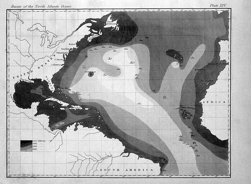
English: "The very earliest rendition of a bathymetric map of an oceanic basin. Matthew Fontaine Maury published this map in 1853 in Explanations and Sailing Directions to Accompany the Wind and Current Charts." |
| Дата | |
| Източник |
http://oceanexplorer.noaa.gov/history/readings/vicissitudes/media/gulf.html |
| Автор | Matthew Fontaine Maury |
Лицензиране
This image is in the public domain because it contains materials that originally came from the U.S. National Oceanic and Atmospheric Administration, taken or made as part of an employee's official duties.
|
|
Това произведение е обществено достояние в държавите, в които срокът на авторското право е 70 години или по-малко след смъртта на автора.
| |
| This file has been identified as being free of known restrictions under copyright law, including all related and neighboring rights. | |
История на файла
Избирането на дата/час ще покаже как е изглеждал файлът към онзи момент.
| Дата/Час | Миникартинка | Размер | Потребител | Коментар | |
|---|---|---|---|---|---|
| текуща | 16:31, 6 август 2011 | | 2201 × 1617 (1,61 МБ) | Belg4mit | {{Information |Description ={{en|1="The very earliest rendition of a bathymetric map of an oceanic basin. Matthew Fontaine Maury published this map in 1853 in ''Explanations and Sailing Directions to Accompany the Wind and Current Charts''."}} |Sou |
Използване на файла
Следната страница използва следния файл:
Глобално използване на файл
Този файл се използва от следните други уикита:
- Употреба в en.wikipedia.org
- Употреба в eo.wikipedia.org
- Употреба в fa.wikipedia.org
- Употреба в fr.wikipedia.org
- Употреба в mk.wikipedia.org
- Употреба в pt.wikipedia.org
- Употреба в tr.wikipedia.org
- Употреба в zh.wikipedia.org