Файл:Roman expansion 264 BC Shepherd.jpg

Оригинален файл (2302 × 1812 пиксела, големина на файла: 873 КБ, MIME-тип: image/jpeg)
| Този файл е от Общомедия и може да се използва от други проекти.
Следва информация за файла, достъпна през оригиналната му описателна страница. |
This image was copied from wikipedia:de. The original description was:
| Описание |
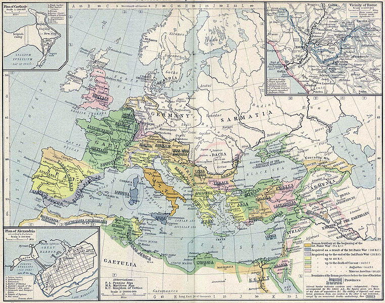
English: Roman territory, from the beginning of the 1st punic war (264 B.C.) to the death of Diocletian
Deutsch: Römisches Reich vom Beginn des 1. Punischen Kriegs (264 v.Chr.) bis zum Tod von Diokletian (312) im Historischen Atlas von William R. Shepherd (1923) |
| Дата | 1923 |
| Източник | "Historical Atlas" by William R. Shepherd, New York, Henry Holt and Company |
| Автор | William R. Shepherd |
| други версии |
|
Това произведение е обществено достояние в държавите, в които срокът на авторското право е 70 години или по-малко след смъртта на автора.
| |
| This file has been identified as being free of known restrictions under copyright law, including all related and neighboring rights. | |
| date/time | username | edit summary |
|---|---|---|
| 18:08, 21. Feb 2005 | Benowar | ("Historical Atlas" by William R. Shepherd, New York, Henry Holt and Company, 1923 PUBLIC DOMAIN) |
История на файла
Избирането на дата/час ще покаже как е изглеждал файлът към онзи момент.
| Дата/Час | Миникартинка | Размер | Потребител | Коментар | |
|---|---|---|---|---|---|
| текуща | 17:08, 18 април 2006 | | 2302 × 1812 (873 КБ) | Crux | verbesserte Version |
| 16:53, 18 април 2006 |  | 2302 × 1812 (767 КБ) | Crux | This image was copied from wikipedia:de. The original description was: {{Information| |Description=Roman territory at the beginning of the 1st punic war (264 B.C.) |Source="Historical Atlas" by William R. Shepherd, New York, Henry Holt and Company |Date= |
Използване на файла
Няма страници, използващи файла.
Глобално използване на файл
Този файл се използва от следните други уикита:
- Употреба в ast.wikipedia.org
- Употреба в ba.wikipedia.org
- Употреба в bn.wikipedia.org
- Употреба в br.wikipedia.org
- Употреба в ca.wikipedia.org
- Употреба в de.wikipedia.org
- Употреба в de.wikibooks.org
- Употреба в en.wikipedia.org
- Употреба в es.wikipedia.org
- Употреба в fr.wikipedia.org
- Употреба в fy.wikipedia.org
- Употреба в it.wikipedia.org
- Употреба в it.wikibooks.org
- Употреба в lv.wikipedia.org
- Употреба в mk.wikipedia.org
- Употреба в mwl.wikipedia.org
- Употреба в pnb.wikipedia.org
- Употреба в pt.wikipedia.org
- Употреба в ru.wikipedia.org
- Употреба в sa.wikipedia.org
- Употреба в skr.wikipedia.org
- Употреба в sk.wikipedia.org
- Употреба в sl.wikipedia.org
- Употреба в sq.wikipedia.org
- Употреба в ur.wikipedia.org
- Употреба в vi.wikipedia.org
- Употреба в zh.wikipedia.org