Файл:Sarychev Peak eruption on 12 June 2009, oblique satellite view.ogv
Размер на този JPG предварителен преглед на изходния OGG файл: 600 × 600 пиксела. Други разделителни способности: 240 × 240 пиксела | 480 × 480 пиксела | 720 × 720 пиксела.
Оригинален файл (Ogg Theora видео файл, продължителност 8,0 сек, 720×720 пиксела, 2,21 Mbps, размер на файла: 2,1 МБ)
| Този файл е от Общомедия и може да се използва от други проекти.
Следва информация за файла, достъпна през оригиналната му описателна страница. |
Резюме
| Описание |
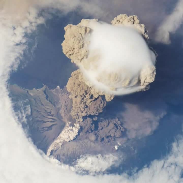
English: A fortuitous orbit of the International Space Station allowed the astronauts this view of Sarychev Volcano (Kuril Islands, Russia northeast of Japan) in an early stage of eruption on June 12, 2009. Sarychev Peak is one of the most active volcanoes in the Kuril Island chain, and it is located on the northwestern end of Matua Island. View faces west.
Français : De façon fortuite, une orbite de la station spatiale internationale a permis à ses astronautes d'observer les phases précoces de l'éruption du Sarytchev, sur l'île Matua, dans les Kouriles (Russie), le 12 juin 2009. Le Sarychev est l'un des volcans les plus actifs de l'archipel.
Русский: Анимация извержения вулкана Сарычева (Курильские острова, Россия) 12 июня 2009 года, зафиксированная с борта Международной космической станции.
Deutsch: Eruption des Vulkans Sarytschew auf der Kurilen-Insel Matua im Fernen Osten Russlands am 12. Juni 2009, aufgenommen aus der ISS.
Ελληνικά: Μία τυχαία τροχιά του Διεθνούς Διαστημικού Σταθμού επέτρεψε αυτήν την εκπληκτική θέα του ηφαιστείου Сарычева (Νησιά Курильские, Ρωσία βορειοανατολικά της Ιαπωνίας) σε ένα πρώιμο στάδιο της έκρηξης στις 12 Ιουνίου, 2009. Η βουνοκορφή Сарычева είναι μία από τις πιο ενεργές στα νησιά Курильские, και τοποθετείται στην βορειοανατολική άκρη του νησιού Ματούα, το οποίο στην τοπική γλώσσα σημαίνει στόμα της κόλασης.
Македонски: Меѓународната вселенска станица го надлетува вулканот Саричев (Курилски Острови, Русија). |
| Дата | Taken on 12 юни 2009 |
| Източник | http://earthobservatory.nasa.gov/NaturalHazards/view.php?id=38985 |
| Автор | ISS Crew Earth Observations experiment and Image Science & Analysis Laboratory, Johnson Space Center, NASA. |
| Object location | | View this and other nearby images on: OpenStreetMap |
|---|
Лицензиране
| This file is in the public domain in the United States because it was solely created by NASA. NASA copyright policy states that "NASA material is not protected by copyright unless noted". (See Template:PD-USGov, NASA copyright policy page or JPL Image Use Policy.) | ||
 |
Warnings:
|
|

| This file was selected as the media of the day for 22 September 2010. It was captioned as follows:
English: A fortuitous orbit of the International Space Station allowed the astronauts this striking view of Sarychev Volcano (Kuril Islands, Russia northeast of Japan) in an early stage of eruption on June 12, 2009. Sarychev Peak is one of the most active volcanoes in the Kuril Island chain, and it is located on the northwestern end of Matua Island.
Other languages
Deutsch: Eruption des Vulkans Sarytschew auf der Kurilen-Insel Matua im Fernen Osten Russlands am 12. Juni 2009, aufgenommen aus der ISS. Ελληνικά: Μία τυχαία τροχιά του Διεθνούς Διαστημικού Σταθμού επέτρεψε αυτήν την εκπληκτική θέα του ηφαιστείου Сарычева (Νησιά Курильские, Ρωσία βορειοανατολικά της Ιαπωνίας) σε ένα πρώιμο στάδιο της έκρηξης στις 12 Ιουνίου, 2009. Η βουνοκορφή Сарычева είναι μία από τις πιο ενεργές στα νησιά Курильские, και τοποθετείται στην βορειοανατολική άκρη του νησιού Ματούα, το οποίο στην τοπική γλώσσα σημαίνει στόμα της κόλασης. English: A fortuitous orbit of the International Space Station allowed the astronauts this striking view of Sarychev Volcano (Kuril Islands, Russia northeast of Japan) in an early stage of eruption on June 12, 2009. Sarychev Peak is one of the most active volcanoes in the Kuril Island chain, and it is located on the northwestern end of Matua Island. Македонски: Меѓународната вселенска станица го надлетува вулканот Саричев (Курилски Острови, Русија). Русский: Анимация извержения вулкана Сарычева (Курильские острова, Россия) 12 июня 2009 года, зафиксированная с борта Международной космической станции.
|
This is a featured media on Wikimedia Commons and is considered one of the finest files.
If you have a file of similar quality that can be published under a suitable copyright license, be sure to upload it, tag it, and nominate it.
|
История на файла
Избирането на дата/час ще покаже как е изглеждал файлът към онзи момент.
| Дата/Час | Миникартинка | Размер | Потребител | Коментар | |
|---|---|---|---|---|---|
| текуща | 22:01, 11 ноември 2010 | 8,0 сек, 720 × 720 (2,1 МБ) | Tryphon | Higher bitrate, from File:NASA ISS June 12 2009 Sarychev Volcano.ogv. | |
| 12:49, 1 ноември 2010 | 8,0 сек, 720 × 720 (1,07 МБ) | Avenue | {{Information |Description={{en|1=A short animation showing an oblique view from the International Space Station of the eruption of Sarychev Peak, Kuril Islands, on 12 June 2009.}} |Source=http://earthobservatory.nasa.gov/NaturalHazards/view.php?id=38985 |
Използване на файла
Следната страница използва следния файл:
Глобално използване на файл
Този файл се използва от следните други уикита:
- Употреба в af.wikipedia.org
- Употреба в ar.wikipedia.org
- Употреба в az.wikipedia.org
- Употреба в cs.wikipedia.org
- Употреба в da.wikipedia.org
- Употреба в de.wikipedia.org
- Употреба в de.wikinews.org
- Употреба в de.wiktionary.org
- Употреба в en.wikipedia.org
- Употреба в fa.wikipedia.org
- Употреба в fi.wikipedia.org
- Употреба в fr.wikipedia.org
- Употреба в id.wikipedia.org
- Употреба в it.wikipedia.org
- Употреба в it.wikibooks.org
- Употреба в it.wikiversity.org
- Употреба в ja.wikipedia.org
- Употреба в mr.wikipedia.org
- Употреба в nl.wikipedia.org
- Употреба в no.wikipedia.org
- Употреба в pl.wikipedia.org
- Употреба в pt.wikipedia.org
- Употреба в ru.wikipedia.org
- Употреба в te.wikipedia.org
- Употреба в vi.wikipedia.org