Файл:Volga.A2002137.0745.250m.jpg

Оригинален файл (4600 × 6000 пиксела, големина на файла: 3,91 МБ, MIME-тип: image/jpeg)
| Този файл е от Общомедия и може да се използва от други проекти.
Следва информация за файла, достъпна през оригиналната му описателна страница. |
http://visibleearth.nasa.gov/view_rec.php?id=3823
Credit: Jacques Descloitres, MODIS Land Rapid Response Team, NASA/GSFC
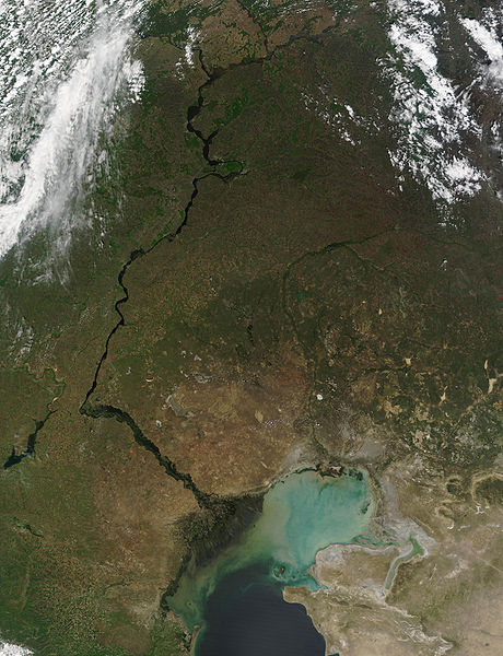
This MODIS image from May 17, 2002, shows the Volga River running north-south and emptying into the Caspian Sea. At lower left, extensive cultivation of the land can be seen in the regular patterns of fields. The light-colored waters of the Caspian Sea may be due to high sediment in the rivers that flow into it, as well as pollution and aquatic plant growth.
Metadata
- Sensor: Terra/MODIS
- Datastart: 2002-05-17
- Dataend: 2002-05-17
- Visible Earth v1 ID 19787
- Visualization Date: 2002-05-24
1. All Sensors 2. » MODIS
| This file is in the public domain in the United States because it was solely created by NASA. NASA copyright policy states that "NASA material is not protected by copyright unless noted". (See Template:PD-USGov, NASA copyright policy page or JPL Image Use Policy.) | ||
 |
Warnings:
|
История на файла
Избирането на дата/час ще покаже как е изглеждал файлът към онзи момент.
| Дата/Час | Миникартинка | Размер | Потребител | Коментар | |
|---|---|---|---|---|---|
| текуща | 21:38, 25 август 2005 | | 4600 × 6000 (3,91 МБ) | Nanosmile | http://visibleearth.nasa.gov/view_rec.php?id=3823 Credit: Jacques Descloitres, MODIS Land Rapid Response Team, NASA/GSFC This MODIS image from May 17, 2002, shows the Volga River running north-south and emptying into the Caspian Sea. At lower left, exte |
Използване на файла
Следната страница използва следния файл:
Глобално използване на файл
Този файл се използва от следните други уикита:
- Употреба в ar.wikipedia.org
- Употреба в as.wikipedia.org
- Употреба в av.wikipedia.org
- Употреба в bh.wikipedia.org
- Употреба в bn.wikipedia.org
- Употреба в ca.wikipedia.org
- Употреба в cv.wikipedia.org
- Употреба в cy.wikipedia.org
- Употреба в el.wikipedia.org
- Употреба в en.wikipedia.org
- Употреба в es.wikipedia.org
- Употреба в gl.wikipedia.org
- Употреба в it.wikipedia.org
- Употреба в lad.wikipedia.org
- Употреба в no.wikipedia.org
- Употреба в pa.wikipedia.org
- Употреба в pnb.wikipedia.org
- Употреба в ro.wikipedia.org
- Употреба в sl.wikipedia.org
- Употреба в tl.wikipedia.org
- Употреба в tr.wikipedia.org
- Употреба в uk.wikipedia.org
- Употреба в ur.wikipedia.org