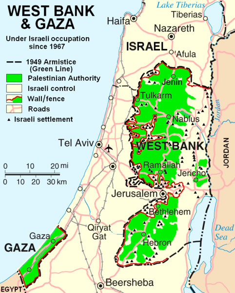
Файл:West Bank & Gaza Map 2007 (Settlements).png

Размер на този преглед: 482 × 599 пиксела. Други разделителни способности: 193 × 240 пиксела | 386 × 480 пиксела | 780 × 970 пиксела.
Оригинален файл (780 × 970 пиксела, големина на файла: 86 КБ, MIME-тип: image/png)
История на файла
Избирането на дата/час ще покаже как е изглеждал файлът към онзи момент.
| Дата/Час | Миникартинка | Размер | Потребител | Коментар | |
|---|---|---|---|---|---|
| текуща | 22:55, 29 октомври 2013 |  | 780 × 970 (86 КБ) | Scott | Correct capitalization in legend. |
| 22:54, 29 октомври 2013 |  | 780 × 970 (86 КБ) | Scott | Correct capitalization in legend. | |
| 06:21, 12 януари 2009 |  | 780 × 970 (105 КБ) | HowardMorland | Replace .gif file with identical .png file <!--{{ImageUpload|basic}}--> |
Използване на файла
Следната страница използва следния файл:
Глобално използване на файл
Този файл се използва от следните други уикита:
- Употреба в am.wikipedia.org
- Употреба в ar.wikipedia.org
- Употреба в ast.wikipedia.org
- Употреба в azb.wikipedia.org
- Употреба в ca.wikipedia.org
- Употреба в ckb.wikipedia.org
- Употреба в cs.wikipedia.org
- Употреба в cy.wikipedia.org
- Употреба в da.wikipedia.org
- Употреба в de.wikipedia.org
- Употреба в de.wikinews.org
- Употреба в de.wikivoyage.org
- Употреба в en.wikipedia.org
- Talk:List of ongoing armed conflicts
- User:Timeshifter/Userboxes
- User:Gimmetrow/test
- User:Gimmetrow/test2
- User:Keizers
- Talk:Jerusalem/Archive 15
- Talk:Palestinian National Authority/Archive 2
- Wikipedia:Top 25 Report/July 13 to 19, 2014
- Wikipedia:Top 25 Report/July 20 to 26, 2014
- Wikipedia:Top 25 Report/July 27 to August 2, 2014
- Talk:State of Palestine/Archive 12
- User:Timeshifter/Userboxes/Palestine: Peace Not Apartheid. By Jimmy Carter
- User:Dare2Leap/info
- User:Timeshifter/Archive 2
- Wikipedia talk:WikiProject Israel Palestine Collaboration/Archive 9
- Употреба в en.wikinews.org
- Употреба в eo.wikipedia.org
- Употреба в es.wikipedia.org
- Употреба в eu.wikipedia.org
- Употреба в fa.wikipedia.org
- Употреба в fi.wikipedia.org
- Употреба в fo.wikipedia.org
- Употреба в fr.wikipedia.org
Преглед на глобалната употреба на файла.
