Файл:Wfm firth of forth.jpg

Размер на този преглед: 800 × 593 пиксела. Други разделителни способности: 320 × 237 пиксела | 640 × 474 пиксела | 1024 × 758 пиксела | 1280 × 948 пиксела.
Оригинален файл (1280 × 948 пиксела, големина на файла: 289 КБ, MIME-тип: image/jpeg)
| Този файл е от Общомедия и може да се използва от други проекти.
Следва информация за файла, достъпна през оригиналната му описателна страница. |
Резюме
| Описание |
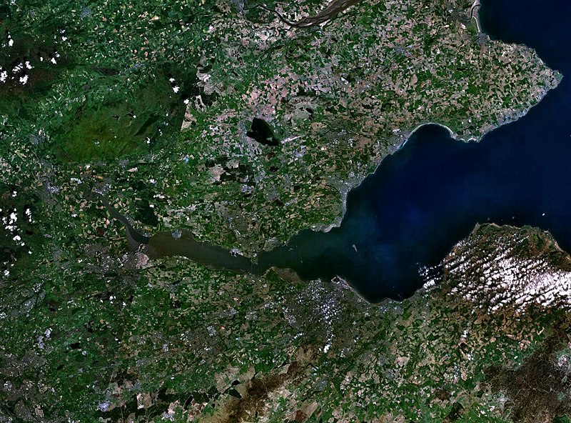
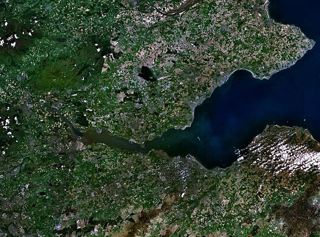
English: The Firth of the river Forth, on the east coast of Scotland. The two forth bridges are visible near the centre of the frame. Stirling is at the extreme left side. |
| Дата | 3 август 2005 (upload date) |
| Източник | Satellite imagery taken by screenshot from NASA World Wind software |
| Автор | NASA |
Лицензиране
| This image is in the public domain because it is a screenshot from NASA’s globe software World Wind using a public domain layer, such as Blue Marble, MODIS, Landsat, SRTM, USGS or GLOBE.
|
 |
История на файла
Избирането на дата/час ще покаже как е изглеждал файлът към онзи момент.
| Дата/Час | Миникартинка | Размер | Потребител | Коментар | |
|---|---|---|---|---|---|
| текуща | 09:38, 3 август 2005 | | 1280 × 948 (289 КБ) | Finlay McWalter | The Firth of the river Forth, on the east coast of Scotland. The two forth bridges are visible near the centre of the frame. Stirling is at the extreme left side. Image made with NASA World Wind. {{PD-USGov-NASA}} category:satellite photos |
Използване на файла
Следната страница използва следния файл:
Глобално използване на файл
Този файл се използва от следните други уикита:
- Употреба в ar.wikipedia.org
- Употреба в be.wikipedia.org
- Употреба в br.wikipedia.org
- Употреба в ca.wikipedia.org
- Употреба в ceb.wikipedia.org
- Употреба в cs.wikipedia.org
- Употреба в cy.wikipedia.org
- Употреба в de.wikipedia.org
- Употреба в el.wikipedia.org
- Употреба в en.wikipedia.org
- Употреба в en.wikivoyage.org
- Употреба в eo.wikipedia.org
- Употреба в es.wikipedia.org
- Употреба в et.wikipedia.org
- Употреба в eu.wikipedia.org
- Употреба в fa.wikipedia.org
- Употреба в fr.wikipedia.org
- Употреба в ga.wikipedia.org
- Употреба в gd.wikipedia.org
- Употреба в ha.wikipedia.org
- Употреба в he.wikipedia.org
- Употреба в hi.wikipedia.org
- Употреба в ia.wikipedia.org
- Употреба в is.wikipedia.org
- Употреба в it.wikipedia.org
- Употреба в it.wikivoyage.org
- Употреба в ja.wikipedia.org
- Употреба в kbd.wikipedia.org
- Употреба в lt.wikipedia.org
- Употреба в mt.wikipedia.org
- Употреба в nl.wikipedia.org
- Употреба в nn.wikipedia.org
- Употреба в no.wikipedia.org
- Употреба в pl.wikipedia.org
- Употреба в pt.wikipedia.org
- Употреба в ro.wikipedia.org
- Употреба в ru.wikipedia.org
- Употреба в sco.wikipedia.org
Преглед на глобалната употреба на файла.